|
|
2002 Bermuda Reports |
|
|
2002 Bermuda Reports |
| Home
Purpose Course Descriptions School Yachts Schedule of Courses Ocean Training Cruises ASA Certification Registration Info Our Location Our People Contact Us |
HALIMEDA had just completed an ocean training
cruise from St Thomas to Norfolk when I arrived aboard on May 20, 2002 to begin
preparation for this, our first Norfolk to Bermuda training cruise of the year.
I attended to several minor maintenance issues that normally occur in the course
of a long ocean passage, and found her to be in very good condition thanks to
the ruggedness of her construction and to the loving, professional care given by
her previous skipper, Captain Hal Sutphen and his crewmembers. After this and
some general cleaning and polishing, I was ready for the arrival of my crew. My five ocean crewmembers arrived promptly on Saturday, May
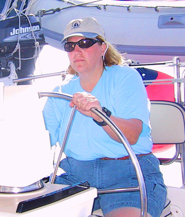
25th; they included: First Mate Jerry Nigro and student crew Robin
Bauer, Ken Crowley, Dave Faison and Tom Swan. This
first afternoon was spent getting to know each other, stowing personal gear,
reviewing plans for the cruise and goals and objectives for each member. Jerry owns a 50 foot cruising sailboat which he has
previously skippered on a round trip Bermuda cruise; he and I have sailed
together on many previous ocean cruises and I have great confidence in his
skills, knowledge and helpful attitude; he's a great shipmate. Robin and
her husband, Mike own a cruising sailboat which they sail extensively on coastal
cruises; they've both taken several of our lower level training cruises and
navigation classes; this ocean training cruise is part of their well planned
program to develop the skills and knowledge needed to sail off into the sunset
at sometime soon. Ken has owned a number of sail and power boats over a
number of years and previously conducted Scuba diving cruises out into the
Atlantic Ocean; he has faced many real ocean challenges in the past and is
undertaking this cruise to sharpen his blue water ocean sailing skills. Dave
owns a 40 foot blue water cruising sailboat, has chartered in several locations
and is planning some future, long distance cruising with his family aboard their
boat; this training cruise is intended provide a some of the hands on experience
necessary to carry out those plans. Tom owns a 26 foot sailboat and has
completed several previous training cruises with our school and is doing this
cruise to learn more of the fundamentals of ocean cruising to help in his
planning for possible future extended cruising. On Sunday, May 26 we began in earnest with our
cruise preparations; I made the following assignments for this phase of
training: Bos'ns: Ken Crowley & Dave Faison; Engineer: Tom Swan; Emergency
Coordinator: Robin Bauer. I'll serve as Navigator in addition to my duties as
Captain, and First Mate Jerry will work with the Bos'ns. We had a full day of
inspections and checkoffs including deployment of all sails, on at a time, at
dockside; winch and line handling techniques; navigation plan; weather reports
and analysis; watch keeping procedures; logbook requirements and procedures;
inspection of all equipment both above and below decks and to the top of the
mast; inventory of all spare parts and tools; review of equipment technical
manuals; review of engine and generator operating procedures; and got to know
the boat and its equipment very well. On Monday, May 27, we continued with review of heavy
weather procedures and equipment including deployment of the complete sea anchor
rig at dockside; Mayday and walkthrough of abandon ship procedures; man
overboard procedures and deployment of rescue equipment; galley procedures;
inventory of onboard food provisions; preparation of meal plans for the cruise;
purchase of needed additional food provisions; and review of weather forecasts
for the next several days. Tuesday, May 28 was our planned departure date and
weather reports were favorable for the next several days. So we completed our
last minute preparations including topping up the water and fuel tanks,
completing pre-departure check lists and stowing loose gear below. I made the
following watch assignments: Watch Section 1from 12 to 4: Watch Captain Dave
Faison & Ken Crowley; Watch Section 2 from 4 to 8: Watch Captain Tom Tursi
& Robin Bauer; Watch Section 3 from 8 to 12: Watch Captain Jerry Nigro &
Tom Swan. These four hour watches will occur twice per 24-hour day so each
person will be on watch for 8 hours per day and off for 16 hours. Meal
preparation duties are also built into the watch schedule with each team
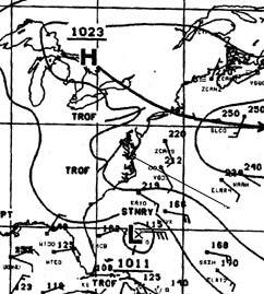
preparing one meal per day and cleaning up the galley once per day. At 10 am, we cast off our lines and departed Little Creek, VA bound for Bermuda. Once rounding Cape Henry at the mouth of the Chesapeake Bay, we set our course of 115 degrees True for Bermuda, 625 nautical miles distant. The weather was bright and clear with light winds of 5 to 10 knots from the SE. We motorsailed on port tack making a course of 145 degrees True placing us south of our rhumb line and thus positioned to compensate from the NE setting Gulf Stream about 100 miles distant. The weather fax showed the normal High pressure region which was centered several hundred miles NE of Bermuda and a Low pressure storm off the Florida coast which was expected to move NE and increase our winds by tomorrow.
Wednesday, May 29 dawned bright and clear with increasing SE winds and fine sailing on starboard tack under full mainsail and genoa. At 0700 we entered the Gulf Stream with a current of 2.1 knots setting northward. By 0800 our winds increased to 20 knots SE; we shortened sail to a deep reefed main and 110% genoa and continued on port tack making slow progress over the ground with the opposing current. The alternative starboard tack was not attractive as it would have sent us way to the north and away from our destination. Winds of 20 to 25 knots SE and waves of 6 to 8 feet continued throughout the day and until midnight when they began to abate. We were sailing along fine making decent progress, but some crewmembers became a little, shall we say, less than enthusiastic about these conditions. Twenty-five knots at sea all day long with no quiet coves to hide are a good introduction to conditions at sea; just enough to give you some respect, but not enough to present a serious challenge.
After midnight on Thursday, May 30 the winds abated and backed to 15 knots E and we were able to sail closer to our desired course, and by noon it backed further so that we could sail toward Bermuda. However, we encountered an opposing current setting at 250 degrees at 2.8 knots, which significantly slowed our speed over ground. This probably was a Gulf Stream meander due to its direction being opposite to the normal Gulf Stream flow for this area. As of 10 am we were 147 degrees True and 210 miles from our Chesapeake Bay departure point; thus we were well south of our originally intended rhumb line had made a net progress of only 110 miles per day... very slow indeed due to the adverse wind direction and now, adverse current. At this time, Bermuda lay 445 miles distant at 102 degrees True.
The weather fax shows a weak low pressure system roughly
centered at our position with expectations that it will move NE and probably
dissipate by tomorrow. And by 9:00 pm, our winds clocked from E to W although
they remained weak. During the morning of Friday, May 31, winds remained
W at 10 knots, and by noon they backed to SW and increase to 12 knots giving us
a great sailing reach on a course directly for Bermuda. This was accompanied by
a clear, bright day with puffy clouds and refreshing, comfortable air
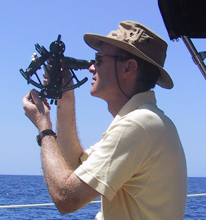
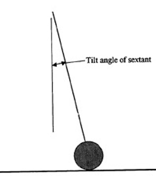
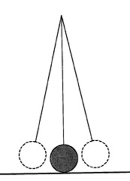
temperatures. Great sailing! Throughout this entire cruise, we have been faithfully keeping a navigational log and a good DR plot using DMA plotting sheets #925 and #926. These allow a good perspective of our route and progress and serve well for plotting celestial lines of position. All crewmembers came prepared to navigate using celestial and all became quite proficient in getting good shots, performing the calculations and plotting the resulting lines of position on the ship's plot. To get accurate shots on a rolling, pitching little boat at sea, it is necessary to master three skills: (1) Adjusting or calibrating your sextant's mirrors, (2) Bringing down the image of the celestial body to the horizon, and (3) Properly rocking the sextant to allow the image to just kiss horizon and to accurately time this moment of kiss. The third step in this process is the hardest for novices to achieve, and it takes persistent practice under sometimes trying conditions to master the techniques.
The key is understanding what a correct shot picture looks like. When the sextant is rocked, the image will appear to be swinging on a pendulum and the low point of the arc is where it must kiss the horizon. A common mistake is to not rock the sextant far enough and thus not find this low point. To help achieve this understanding, I conduct a training drill as follows: The student brings down the sun's image, rocks the sextant and marks the time of kiss. At that moment, I read our GPS position. I then use my celestial computer and enter the student's altitude and time and enter the GPS position as the Assumed Position. Theoretically, if the shot was completely accurate, the Intercept should calculate as Zero; if the number is large, say 15 or 50 miles, then the shot picture was incorrect.
Now, here's the important point... to make this work as an
effective learning technique, it's essential to take repetitive shots as
discussed above until the Intercept comes down to 1 or 2 miles. And this
repetition should be in the same session, not hours or days apart, to allow the
student to recognize cause and effect and to achieve consistent accuracy. Once
this accuracy is achieved, we put away the GPS and celestial computer and go
on to the next step in ocean navigation, which is to perform manual sight
reductions and put lines of position on the plotting sheet. Saturday, June 1 started as a cloudy night with winds of 10 knots S and we continued to sail on starboard tack toward our destination. As daylight came, skies gradually cleared and winds remained light from the south which gave us an easy reach at 5 knots.
By Sunday, June 2 winds clocked to dead astern at 5
knots and we struck our sails and motored most of the day. As we were now
approaching the western end of Bermuda, I left Special Orders with the night
watch to waken me before crossing longitude 65 degrees- 05 minutes West;
eventhough we were well north of the Bermuda latitude, this was a precaution
that I commonly use when approaching a landfall. On June 3rd the night watch woke me at 0140 as we crossed this longitude and at 0430 hours we sighted North Rock Light bearing 170 degrees magnetic... right on schedule! At 0530 we sighted land (Land Ho!!) off our starboard bow. We called Bermuda Harbour Radio on VHF, identified ourselves and requested permission to enter Town Cut Channel into St Georges. By 0900 we passed through Town Cut and by 0930 we were cleared in through Customs.
This was a relatively slow passage due to the adverse winds
and currents causing us to sail 760 miles as compared with the rhumbline
distance of 610 miles. We completed this distance in 5 days and 20 hours for an
average daily run of 130 nautical miles. Captain Tom Tursi
|