Home
Purpose
Course Descriptions
School Yachts
Schedule of Courses
Ocean Training Cruises
ASA Certification
Registration Info
Our Location
Our People
Contact Us
|
| Course: |
Offshore Passage Making; Bermuda to Norfolk |
| Date: |
June 28-July 05, 2010 |
| Vessel: |
IP440 CELESTIAL
|
| Students: |
Michael Brown; Paul
Goswitz; Mike Poole; Tom
Przybelski |
| First Mate: |
Jerry Nigro |
| Captain: |
H. Jochen
Hoffmann |
|
Pre-departure
Preparation, June 28-29, 2010
I had arrived two days early to overlap with Norfolk to Bermuda ASA108 Captain
Tom Tursi and First Mate Jerry Nigro to check with them on the condition of CELESTIAL.
We conclude she’s in excellent shape and requires only minor maintenance to be
ready for sea. I have previously sailed with Jerry on numerous MDS ocean
voyages, and will welcome his expertise on this one. We make final preparations
and soon it’s time to welcome our new shipmates who are about to arrive by
plane.
The two days of dockside training cover carefully thought
out topics as presented in detail in the MDS text Offshore Training Cruises
Preparation Guide. Students had been asked ahead of time to study this book
to make them aware of the intensive training that awaits them. Under sunny
Bermuda skies, they learn to use CelestiaL’s
offshore equipment, including storm trisail, sea anchor, collision matt, and
other safety equipment. Then we move below decks to
explore the systems of this modern ocean yacht, make meal plans and a
provisioning list before focusing in detail on route planning and navigation
plotting procedures. After an enjoyable dinner ashore, I show my students how to
set up NIMA plotting sheets for underway navigation and assign these lead crew
roles: Tom – bosun, Mike – emergency coordinator, Michael –
engineer, and Paul – navigator. To be sure, everyone needs to know about
everyone else’s role and, in fact, all will take turns as navigators. Anticipating
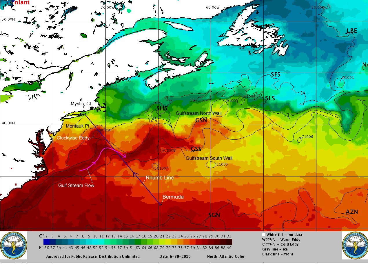
our Gulf Stream (GS) crossing, I explain GS features using the latest GS chart
print out (see below). Next,
students develop a detailed navigation plan while others shop for the provisions
that we have mutually agreed upon. Finally, we turn in early to get a good
night’s rest before departure.
Day 1 at Sea
Last night, after dinner at the fabled White Horse Inn, we cleared customs
since all was ready for departure. Early this morning the only thing left to do
was to top off fuel and water and check in with the Maryland School Office. At
0830 Bermuda time, we obtain departure clearance from Bermuda Harbour Radio and
cast off. First, we make our way through Town Cut, and at 0935 - following
Paul’s navigation plan – we reach the start of our rhumb line course to
Montauk Point, NY just north of Northeast Breaker Light. As the crew settles
into watch routines, four eager celestial navigators focus on procedures to fix CELESTIAL’s
position using the sun. Some are successful on their very first try and all
compare notes as to sighting and reduction procedures. A steady, gentle breeze
at 12 knots from SW has us moving comfortably at 5 plus knots into the evening
under full sails.
Day 2
We collect weather (wx) forecasts from onboard sources such as CELESTIAL’s
Single Sideband Radio, Skymate satellite system, Navtex receiverand via
satellite email from Captain Tom Tursi who writes: "At
0000 UTC 7/1 a Cold Front extends from 36N70W to 40N61W. At 0000 UTC 7/2 Low at
34N71W to move East Northeast and produce Southwest winds 35 knots along the
cold front. Expect winds N-NE 15 knots on Friday north of the cold front."
In short, watch out for squalls. At 0800
we log our position as 33°42'N,
66°16'W;
forecast winds are SW 12-16; our course is 335 degrees per ship’s compass (psc),
and speed is up to 7 kts. It’s glorious sailing since yesterday in SSW winds
12-15 kts. All four celestial navigators take multiple sights on sun, moon, and
Venus. Good position fixes are their rewards – and big smiles all around. At
nightfall we practice man over board (MOB) drills. Happily, all is well.
Day
3
At 0900 our position is 35°05'N,
067°33'W;
wind is NE 15 to 25 knots; barometer rising; and the course is still 335 degrees
psc. Yesterday’s forecast held true: first squalls arrived in the afternoon
followed by the cold front in the evening. The center of the Low hit us at 0200
with backing winds between 30-35 knots. Our already deep reefs were finally
reduced to a triple-reefed main and a scrap of jib when it became time to
heave-to. Forereaching at a mere 1 kt things aboard became wonderfully calm.
Crew and boat did great. For today, under clearing skies, our navigator of the
day has worked out a course west of our rhumb line that will intercept the Gulf
Stream’s bulge as it turns NE – giving us an extra boost from its 2 knot
current toward our rhumb line.
|
 |
Click
thumbnail for an enlarged image |
Day
4
Course calculations are on target as we approach the Gulf Stream bulge and will
be riding its current for the next 20 hours. Although winds are NE – an
undesirable, opposing direction to the Stream’s current – they are light
enough for the crew to concentrate on repairing the jib which had sustained
three tears between one and nine inches during the squalls of the night before.
And before long the jib is up again. The loss of one radar reflector during the
same squall is not critical since CELESTIAL carries redundant equipment.
Day
5
Today is Fourth of July and our VHF radio picks up chatter about offshore
boaters making plans to celebrate the day. We mark the day by making landfall
preparations. The navigator logs our 0800 position as 38°41'N,
070°56'W
which puts us 140 miles south of Montauk Point. Winds have backed to a favorable
direction – NW at 18 to 22 knots keeping boat speed around 7 kts. Just before
sunset, students working on compass calibration exercises using the sun.
Invariably, they are amazed by their results which indicate clearly that the
method works
 Day
6 Day
6
At 0615 Mike and Tom who have the morning watch report “Land Ho.” Montauk
Point is in sight. And soon thereafter they spot our landfall target, the Mo
“A” sea buoy. This marks the end of ocean navigation and the beginning of
careful coastal piloting according to a succession of plans worked out by Tom,
Mike and Michael. They take great care to get us past the rock-strewn east end
of Fishers Island and into the Mystic River. I call U.S. Customs as
required but get repeated voicemail requests to call back. It’s a holiday
weekend and they are short staffed. After topping off fuel in Noank, we tie up
in our assigned slip at Mystic Shipyard where we make contact with Customs which
sends an officer who clears us in. Farewells seem anticlimactic since our hearts
are still at sea.
To my
terrific crew: Thank you for a job well done – and God speed, always.
Captain
H. Jochen Hoffmann
S/V CELESTIAL, IP440
Mystic, Connecticut
Return to Home

|