Home
Purpose
Course Descriptions
School Yachts
Schedule of Courses
Ocean Training Cruises
ASA Certification
Registration Info
Our Location
Our People
Contact Us
|
| Course: |
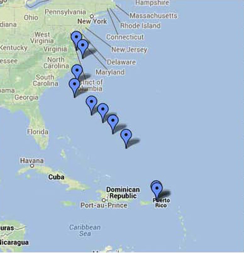
Ocean Training Cruise, St Thomas, USVI
to Norfolk, VA |
| Date: |
May 5-17, 2013 |
|
Vessel: |
S/V CELESTIAL, IP440 |
| Students: |
Glenn (Skip) Stebbins,
Adrian Gnyra, Joseph Pazourek, Richard Westrick (participated during
prep phase) |
| Mate: |
Captain
Steve
Runals |
| Master: |
Captain
H.
Jochen Hoffmann |
List
of Abbreviations
used:
| BDA |
Bermuda |
| CF |
Cold Front |
| DR |
Dead
Reckoning Navigation |
| GS |
Gulf Stream |
| HP |
High Pressure
weather system |
| Kt |
Knots
= Nautical
miles per hour |
| MOB |
Man
Overboard |
| N, E, S, W |
North, East, South, West |
| NM |
Nautical Miles |
| PSC |
Per ship’s compass |
| SSB |
Single Sideband Radio |
| T |
True
direction relative to North Pole of Earth |
| Wx |
Weather |
Crown
Bay Marina, St. Thomas, USVI, Sunday, April 28 to Saturday, May 4, 2013:
I have stayed on CELESTIAL after my just-finished Virgin Islands
class to perform maintenance, test all systems, and retrieve our extensive ocean
gear from storage. To ready the boat for our ocean crossing, I also arranged for
experts to inspect or repair all sails, all standing rigging, electronics, the
steering mechanism, hull and rudder, and to service engine and generator. Fellow
MDSchool Captain and friend Steve Runals, who has himself completed many ocean
trips, arrived May 3 with a new steering wheel. Great! We install it right away.
Our
student crew arrives May 4. They are a group of experienced boaters who seek
more intense blue water exposure: Adrian owns an Island Packet, Joe has
completed an offshore class with me before and wants to build on that, Skip and
Richard Westrick (Rick is joining us for the two-day preparation phase) are
longtime boating partners who want to cross the Atlantic and are looking for the
“right” type of boat. Over dinner we all get to know one another.
Sunday,
May 5 in port:
We begin two days of dockside training to familiarize the crew with systems and
electronics below, lines and sails on deck, and all safety gear. This includes
breaking out our offshore medical kit, collision tools, life raft, manual bilge
pump, etc. Adrian has volunteered to go up the mast “for practice” and to
inspect rigging and lights, and Steve is taking the lead showing rigging of our
boom crutch and storm trysail. After lunch, we gather below to make a meal plan
for the trip, buy and stow food and supplies, and ensure that refrigerated items
cool down completely before we switch from shore power to battery power. Next, I
show how we would rig and deploy our multi-part sea anchor in case of heavy
weather and how we stow it. We then stow the port anchor below, and I
demonstrate safe handling of our electric windlass that controls our heavy
starboard anchor. By now, the sun is setting, and we are eager to take a shower
and have dinner.
|
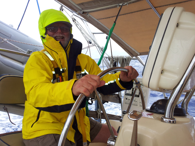
 |
Click
image to enlarge |
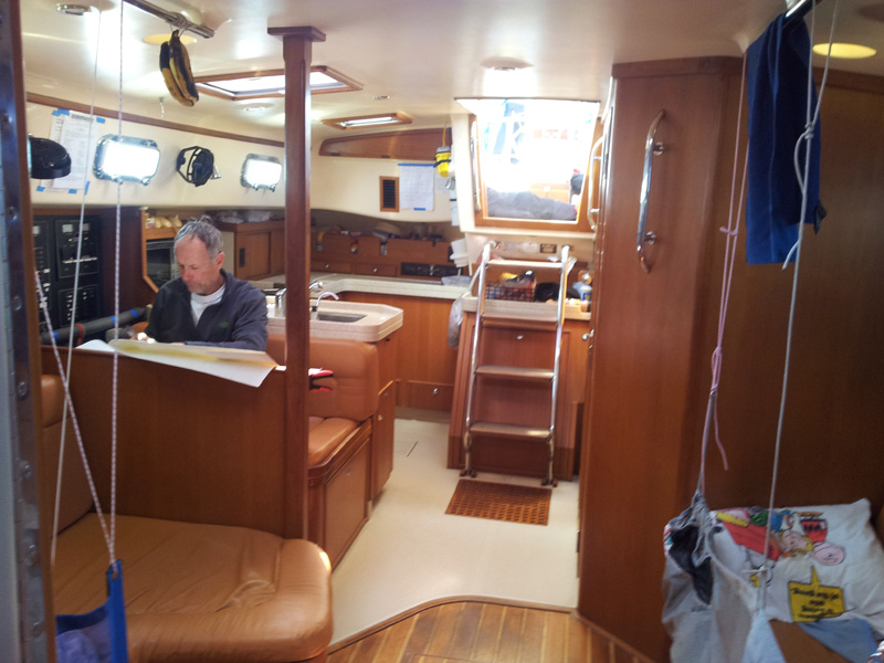
Monday,
May 6 in port:
Students had weeks to prepare at home, using the MDSchool’s Offshore
Training Cruise Preparation Guide. I now review such key topics as medical
emergencies (we have a contract for such a purpose with a special medical team
ashore), fire, abandon ship, etc. I now make related crew assignments for the
voyage: Adrian – emergency coordinator and navigator; Joe – engineer; Skip
– boatswain (bosun); and Steve, a licensed Ham operator, had agreed earlier to
take on such topics as SSB communication, weather, and GS currents. All go to
work now to familiarize themselves with the location, inventory, and
state-of-readiness of their assignment-specific gear.
Steve
and I analyze weather data for the next five days collected from various
sources. Chief among those is a comprehensive thirty-page weather data package
faxed to us today from Tom Tursi of MDSchool of Sailing. Tom will monitor the
U.S. National Weather Service and Bermuda Weather Service and give us daily
forecasts by email over our Skymate satellite transceiver. Tom’s data gives us
first a macro view of trends between central U.S. and Europe between our
latitude up N to the Canadian Maritimes and Iceland. He has also sent us
Internet GS charts and charts of frontal boundaries plus wind and wave charts
that show us what to expect in the near term.
Adrian,
together with Steve, sets up a detailed navigation plan for our departure. I
break out and explain the Atlas of Pilot Charts which shows for the
world’s oceans, and for each month of the year, nineteen-year averages of wind
directions and strength, shipping routes of the world, and equal lines of
magnetic variation from true North – among many other data. We need that data
to make up our own charts, called a Plotting Sheet, to span the vast spaces of
ocean beyond those coastlines where available marine charts are normally used. The
preprinted Plotting Sheets are mostly blank showing merely 15° of latitude
North or South each between the equator and the earth’s North or South Poles.
Also, only lines of longitude without degree designations are printed. That
allows us to pick and write our own degree labels based on the Meridians we
expect to cross. Next, we draw a rhumb (or direct) line from Savannah Passage in
the Virgin Islands to Cape Hatteras, Virginia, some 1,387 NM away on a projected
course line of 333° True. Actual distance sailed will be greater since we shall
steer courses based on wind, weather, or current consideration. But we measure
our progress against this rhumb line. It is now late in the evening, and
we are almost ready to cast off.
Tuesday,
May 7 - Day 1 at Sea: DR (Dead Reckoning) Navigation:
After breakfast, we finish our assigned tasks, top off fresh water, check
officially out of the Marina Office and disconnect shore power cords and docking
lines. We are ready and depart Crown Bay Marina at 1000 only to anchor in nearby
Honeymoon Bay. Here, Adrian has volunteered to jump into the water and rig a
rudder safety line as a potential stabilizer in case of heavy weather. Once our
anchor is up, we review and practice one of several MOB procedures we need to
know in case of a real emergency. Finally, we motorsail in near calm conditions
to the W-end of St. Thomas. From here, we steer 338° psc through the Savannah
Passage, where, at 1200, we mark our departure waypoint at the N-end of Savannah
Island. Our course to our first waypoint is 320° True.
Since
I had earlier assigned shipmates to their watches, we now assume our watch
duties as follows, 12-4: Joe Pazourek and Skip
Stebbins; 4-8: First Mate Steve Runals alone with autopilot; 8-4: Captain and
Adrian Gnyra. Before we settle into our watch routine and literally “sail
off” our coastal chart, I review a central aspect of ocean passagemaking: the
conventions and procedures of dead (or deduced) reckoning navigation. To this
end, we need to know how to plot and label DR course lines on our Plotting
Sheets, and how to convert course values from a ship’s (magnetic) compass
heading which we use at the helm to True heading mariners record on charts and
vice versa.
We
also need to know how to enter celestial lines of position we have obtained from
calculations of measured sextant angles of celestial bodies that we “shoot”
and the procedures to combine lines of position to achieve a celestial fix
position that tells us where we are on this big ocean. Only then can we restart
our DR plot.
Day
2 at Sea: Weather Forecasting and Current Sailing:
Our 0800 position is 18°53.69' N; 65°03.72' W. Sky overcast, intermittent
showers. Tom Tursi’s email forecast reads: “Atlantic High settling in for next several days. Expect Trade
Winds E 10-15 below 25°N latitude and clocking S to SW as you proceed to NW. No
Lows in near term.” Indeed, the Trade Winds have finally retuned and now blowing E 15-18, gusts
higher. Knowing that CELESIAL sails faster when more upright, our
sail plan shows a double reefed main, single reefed jib, and full staysail.
Course is 335° psc, speed 6 knots.
Shipmates begin to carry out assignments in their “off” hours
made earlier, including setting up two more Plotting Sheets for the latitudes we
will transit. Steve, who has taken on SSB weather and Atlantic currents had
earlier provided background and explained the advantage of entering waypoints on
the Plotting Sheets. He had given
an excellent weather seminar and also explained (by way of a recent Gulf Stream
current chart) how GS eddies can help or slow our progress. Namely, eddies -
having separated from the GS and existing for weeks and often far away from the
GS – maintain a clockwise (warm eddy) or counter-clockwise rotation (cold
eddy) of up to 2 knots. Students are learning how to make use of them. (We all
need a break!) After days of intense physical and mental efforts, Joe and
Skip’s chicken dinner tastes really great. Great cooks!
Day
3 at Sea: Celestial Navigation:
At 0800 we are at 21°025’N, 067°35’W. Our noon-noon plots show that we
have covered 124 NM, at a decent average speed of 5.2 knots. Wind has clocked to
ESE 10-16, cloudy skies with intermittent rain. Most of the Captain’s stowed
clothes have gotten wet. Where is the leak? Bosun Skip traces a bead of water
back to mast and ceiling and applies silicon sealant. Better! For today’s
training topics, I briefly include the much anticipated Sextant. Student crew
breaks out their instruments, and we review handling and rocking the
sextant.
Then
we practice “shooting” using sharp cloud contours in the absence of the sun.
Given the boat’s rolling, pitching motion, the word patience takes on a whole
new meaning. Discussions on how sun lines of position are calculated and entered
on our plotting sheets follow. We try getting a weather update via SSB radio,
but propagation is too poor. Based on Tom’s first weather package and
observation of the falling barometer, we conclude that we have reached the
stationary frontal boundary. For the night we expect rough conditions and use
our roller furling systems to reef (reduce) sail area.
|
|
|
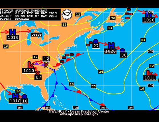
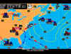
NOAA Weather Chart, 7 May 2013 |
Day
4 at Sea: Storm Squalls and Whales:
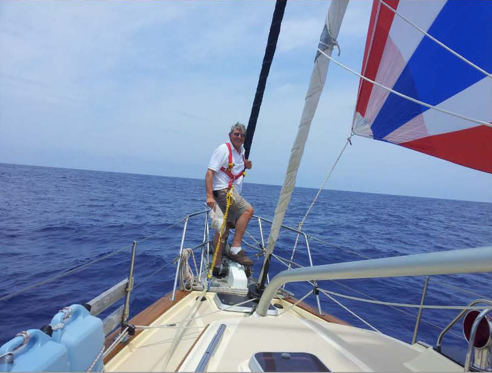
Last night’s watches, sailing deeply reefed, had their hands full as strong
squalls overtook us. At 2145, gusts up to 38 kts, Adrian at the wheel, we reefed
the jib even further – down to a scrap of sail. As we brought the wind to our
starboard quarter to flatten the boat, gusts gripped the bimini and I started to
take it down. Fortunately, the wind decreased, stayed in the 20s making matters
more manageable. Course is 344° T to the No 2waypoint, 250 NM away.
Tom’s
wx email signals that more will be in store for us: “Intense
Low over Canadian Maritimes drags Cold Front offshore Mon = SW gale NW of BDA.
Another Low off Hatteras Mon moving NE.” As Steve picks up an SSB weather report
as well, Skip marks the front on our weather chart, while Joe (great engineer)
and Adrian check engine fluids and pump the bilge. This crew is adjusting well.
Our reward:
The afternoon watch alerts us to a whale mom and calf blowing repeatedly nearby.
To boot – three beautiful Bermuda Longtails have been circling our mast.
Day
5 at Sea: More Current Navigation:
Position at 0800 is 25°28’ N, 069°25’ W. To start the day, the Captain
makes pancakes and hash browns. After four days of overcast, rainy, squally
conditions, finally some sun. Although seas and swell are still high, students
grab sextants and practice sun shots. They use the Captain’s sun fix and learn
how to restart a DR course from a known position. But rather than plotting a
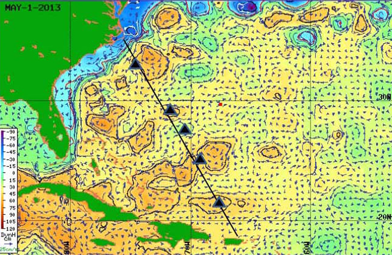
straight rhumbline course toward Cape Hatteras, we lay out course lines to five
waypoints marked on our Plotting Sheets by Steve. As he explained earlier, those
waypoints are positioned to give our boat a push from perimeter currents of warm
and cold eddies ahead of us. They make our way to Norfolk look a bit like a
slalom course. But by examining the current vector on our electronic chart
plotter, we see the positive results. Currents of 0.75 to 1.5 knots are most
often on our quarter or stern, rather than on our bow. The result: 24-hour speed
over ground has been boosted to 157 NM or 6.6 NM on average. Course to waypoint
No 3 is 313°T. As to SSB weather, reception is improving, due to decreased sun
spots as we learn, but most stations still cannot hear us yet.
|
|
|
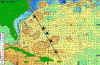
Ocean Currents & Waypoint Predictions as of 1 May
2013 |
Day
6 at Sea: Routines and Safety Training:
Position 27°08’N, 071°14’W. We are
under sunny skies. To catch the last of the dying Trade Winds, Steve shows how
our spinnaker is set. Spirits remain high, even though the spinnaker has to come
down and we need to start the motor. All have settled nicely into our daily
routines. They include - outside of sleep and rest during the eight hours
between watches – morning boat cleaning, meal preparation and saltwater dish
washing (freshwater rinse), SSB watch or communication via satellite with the
MDSchool Office, log keeping, and boat maintenance. For example, Skip has
repaired a wind-torn bimini strap, Joe has refastened loose hinges and looked
after the engine and generator, and Adrian has taken down SSB weather reports
along with Steve or the Captain so that we would not miss information whenever
reception was poor. Daily training has so far included MOB practices under motor
and sail plus such topics as firefighting, collision, and abandon-ship
procedure. All along, celestial navigation practice continues as we head to
waypoint No 4 on a Course of 320°T.
Day7
at Sea: Weather Routing:
Our 0800 position: 28°43’N, 072°47’W. Motoring in calm conditions since
noon yesterday tells us that we are in the so-called Horse Latitudes. We raise
the main sail at noon in gentle SW 10 and are now motor sailing. Still, the
current is pushing us at 1+ knots, giving us good ground speed. Students are
getting much better at their celestial navigation and are excited about it. I
have finally established contact on SSB channel 155 with famous weather router
Herb Hilgenberg, call name Southbound II, who analyzes for us local conditions
ahead and cautions about the front with gale-force winds moving to N of BDA.
It’s the one Tom Tursi had signaled earlier by email. But winds at our
location are now at N 18-20 while at 25-30+ to the N of us. Herb advises that we
continue W to stay below latitude 30° N. We shift our course to 255°True and
sail deeply reefed into the night. In short, weather considerations trump
current navigation. Also, to be safe, progress to our goal slows as we detour
happily WSW then W - away from the low.
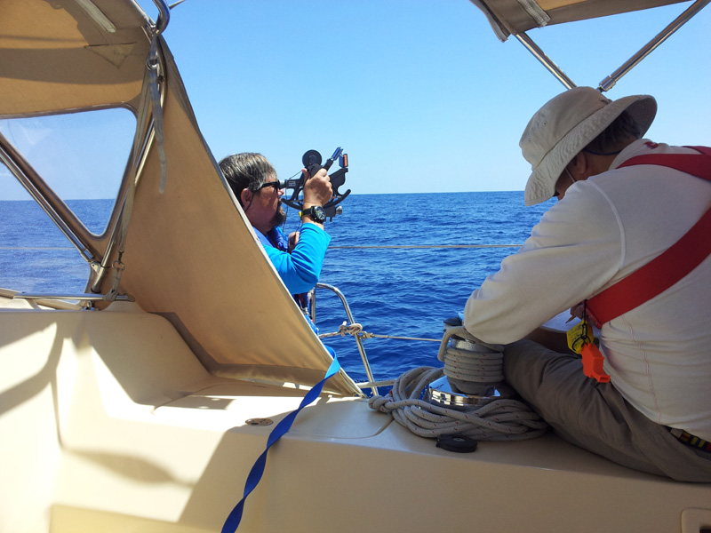
|
|
|
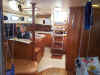
Steve checking navigation chart |
Day
8 at Sea: Shooting the Sun:
Although the wind would gust to 28 knots last night, we took it just abaft the
beam with acceptable heeling because of our reduced sail plan. As on previous
occasions, all of us would either extend our watch hours a bit or go on deck to
give lonely Steve a break or provide nourishment during his 4 to 8 watch
periods. By 0800 we are at 29°38’N, 074°06’W.
Per Herb’s weather routing, we have remained safe below latitude 30° N, but
believe we can steer now 315°psc since the wind is clocking and remaining on
our quarter. Our propeller has caught some debris (Sargasso Weed? Parts of a
fish net?) which subsequently shook loose. Students have gotten so accomplished
in shooting the sun that those resultant lines of position make for very good
fixes allowing us to restart our DR course each time. They are ecstatic. At 1630
Herb advises boats near BDA over SSB to ride out the gale in their area at sea
and not attempt landfall in BDA. For us he is still monitoring the low off
Hatteras and advises we go into Beaufort, North Caroline to let it pass out to
sea. But since winds are forecast to decrease and veer to the SW – again a
favorable quartering wind – this now experienced crew considers all options
and is comfortable with the decision to change course northward toward Diamond
Shoal off Cape Hatteras.
Day
9 at Sea: Sail Change and Landfall
Preparation:
At 0630 Steve alerts me that a three-foot panel of our older, roller-furled,
reefed mainsail is beginning to tear. As winds have dropped below 10 knots, we
quickly unfurl and drop the sail and replace it with a newer sail that we carry
as a spare. By 0800 our position is 31°52’N 076°45’W; course now is 340°psc.
At this angle we are rapidly closing with the Gulf Stream perimeter currents. We
unfurl the full jib and run its sheet through our whisker pole thus holding it
full and drawing as the wind is coming from behind. Time to make landfall
preparations. They include breaking out proper coastal charts, reviewing the
Light List regarding major buoys and navigation lights ashore, and reviewing –
yet once more – the various navigation lights ships might display at night. A
big day ends with elation: We have entered the Gulf Stream at 2000 hours based
on water temperature readings and current velocity.
Skip has seen dolphins. I am supposed to write in my daily emails to the
School that CELESTIAL has “a happy crew."
Day
10 at Sea: Gulf Stream Crossing:
Position 33°11’N, 076°12’W. Winds increased during the night and have
stayed at 20-25 knots under clear skies – still from the favorable SW
direction. Although we have been
carrying just a scrap of main sail and reefed jib, our speed over ground is an
amazing 8-10 knots, thanks to the current. But, it wasn’t the Gulf Stream just
yet last night, perhaps only a warm eddy pushing us at consistent 2+ knots.
By 0800 consistent water temperature of 81°F and increased current tells
us we have reached the East Wall of the Stream. Lots of ship traffic here. Ten
hours later, at 1800, the temperature drops: We have passed the West Wall. We
head for and round Diamond Shoal off Cape Hatteras at 2300. During our approach
to Diamond Shoals Light, we look at our chart plotter. It shows that our AIS is
picking up seventeen ships – all heading S. We keep a sharp lookout for
traffic as we turn 000°psc toward the Chesapeake Bay Entrance, sailing along
the North Carolina shore. Noon-to-noon entries show we have progressed 200! NM
– the greatest 24-hour distance the boat has ever recorded; average speed over
ground 8.3 knots. It’s an incredibly satisfying feeling for all of us.
Day
11 at Sea: Landfall:
At 0800 we are E of the popular beach of Duck, NC at 36°00’N, 075°32’ W.
We have concluded our DR navigation once we had sailed ourselves into an area
covered by coastal charts and switch to piloting procedures instead. The wind
has dropped below 5 knots, and we are motoring up the coast over flat seas,
sails finally furled for good. Cell phone service allows us to call family, the
MDSchool Office, and our Marina in Norfolk. At 2115 we tie up at the fuel dock
of Vinings Landing Marina in Little Creek, Norfolk, toast one another and fall
into our bunks – tired but extremely happy.
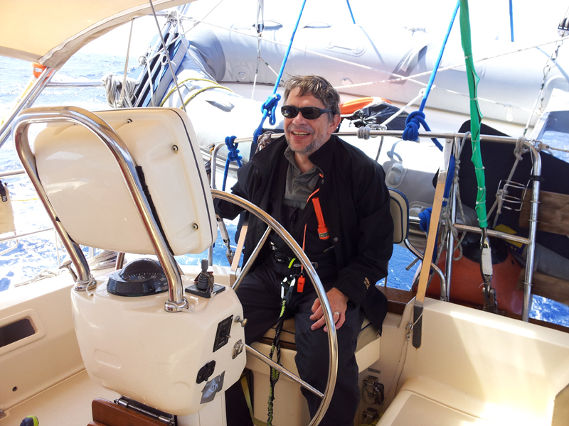
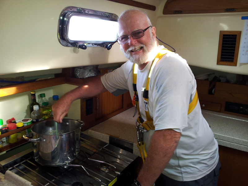
|
|
|
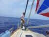
Captain Jochen at Landfall |
In
Port - Norfolk, VA, Saturday, May 18, 2013:
A myriad of details needs to be tended to – from refueling, docking, watering,
cleaning, and tending to maintenance. The computer technician has arrived to
work on the ship’s computer. The torn main sail is loaded into Steve’s truck
so he can take it to the sailmaker for repairs. Hotels or flights are being
booked and one car rented. One more lunch together and we bid each other a fond
farewell. What stories my great shipmates will be able to tell. Your Captain and
Mate thank you for a job so well done.
Cruise
Statistics:
| 1,578
NM |
Distance
Sailed |
| 71
gallons |
Fuel
Consumption (engine and generator) |
| 10
days and 9 hours |
Time
at Sea (from Departure Waypoint) |
|
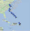
|
|
Route positions as shown on our tracking blog |
Captain Jochen Hoffmann
S/V CELESTIAL
Norfolk, VA
May 18, 2013

to Ocean Reports
Return to Home

|