Wednesday, June
20, 2018. Day 1
After introductions and cruise overview, we begin the day with line
handling practice and, then, dinghy operation in the harbor. Boat check below
and above deck conclude with deck and winch safety practice. While
the student crew develops nav plans for days 1 and 2, the captain shops
according to the meal plan all had agreed on. We cast off and begin with the
most challenging of all anchoring evolutions—the med mooring. With Rich
carefully tending the anchor rhode, Keith steers and moors the boat on first
try. By 1630, we are underway per the nav plan, execute a safe entry into
narrow Queenstown Creek where we anchor for the night and enjoy a simple
dinner in the cockpit.
Day 2
Each student crew will now develop a nav plan and act as skipper for each
alternating day. Off Queenstown Creek the next morning, and after Rich places
a security call on VHF radio that AcaDame will be conducting MOB drills,
we practice MOB maneuvers of ever increasing complexity, including use of the
all-important MOB-button on the captain’s plotter. That done, the crew finds buoy G “9” Fl G 4s (previously
checked in the Light List [LL]) by simply following the depth contour of 30
feet, as intended. Now, the wind picks up and we can raise sail, practicing
firm halyard control. As we proceed toward the Chester River entrance buoy R N
“2”, we learn a critical lesson: Be alert-- always!
A “Head Boat”, i.e., a commercial boat with recreational anglers on board
and returning to port, is coming straight at us. We need to give the emergency
signal twice and rapidly alter
course as collision avoidance measure before the captain sees us and bears
away. Once we are around Love Point (entering LL # 8340 for students to
recognize the navigational importance of this mark), we are close reaching
toward the Bay Bridge, inspecting range lights and the mid-channel sea buoy RW
“LP” Mo (A) along the way. Finally arriving in Annapolis, we practice
picking up a mooring. Having used two doubled-over lines from each bow cleat
to the mooring ball pennant to form a bridle, means great peace of mind if a
strong squall moves through.
Day 3
Still secure at our mooring, the morning is filled with engineering tasks
plus advanced navigation topics cruisers should be familiar with. That
includes once more a close look at the U.S. Coast Guard
Light List and how to make effective use of the wealth of information it
provides to all mariners. We consider key waypoint (wpt) marks on our route
and what limited chart detail vs. Light List may say about them. For example,
the once 54’ high Bloody Point Light as marked on older charts now has a
brand new, multi-pile structure with a white warning beacon right next to it.
The Light List shows that the venerable, tall, brick Light House (old LL #
7750) had been replaced by a mere 22’ high warning light (LL # 7751) to mark
the remains of the Light House. In driving rain, two reefs properly set per
our IP-32 main sail rig plus a reefed jib set, we sail to the West River
intent on docking at Pirate’s Cove. “Sorry, all slips reserved” is the
contact’s response. We are to check again after 1700 in case of a possible
no-show. We anchor, review text topics, and finally get slip # 25 where we try
to dry out and have dinner.
Day 4
Today, Rich as skipper, we start navigating at that advanced level that
distance cruisers will want to master. Dead Reckoning (DR) plus compass
conversion to, and plotting in relation to, True North--all discussed
earlier—are part of it. All route planning was done in the ship’s log. Our
Rhumb line is: West River to Tilghman Point, using Chart 12270—Eastern Bay
and South River. Students have captured all essential information needed to
ensure a safe passage along each leg—from the description of navigational
aids to the latitude/longitude position. (See their entries below.)
|
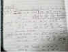
|
Click image to enlarge |
For Leg 2:
Course plotted is 126ºT =
136ºpsc to steer to reach the next waypoint. Distance 4.6 NM.
For Leg 3:
Course plotted is 057ºT =
068ºpsc to steer to reach the next waypoint. Distance 6.5 NM.
On our way, students take bearings to fix our position.
They also successfully hail the Maryland School’s ocean yacht NAVIGATOR--used
for ASA-108 and 106 classes--which is on her way back from Bermuda, currently
doing an ASA104 class up the Bay to her home port from Norfolk.
Near Bloody Point, we alter course to afford safe passage
to a North-bound container ship. From buoy Red “4” Fl R 4s, students
discuss and settle on one of many navigational options that are now part of
their skill set to reach Tilghman Creek. Once in the Creek, our newly minted
cruising sailors practice setting two anchors forked off the bow before
settling down and enjoying dinner in the cockpit.
Day 5
We rose before sunup, recovered both anchors, and navigated out of the
channel as the sun was rising ahead of us. Today, the crew is running the
boat, Keith as skipper and the captain coaching only to achieve a smooth
transit through tricky Kent Narrows with its Bascule bridge and strong
current. A delightful downwind run, preventer in place, came with one
concerning last challenge: As we furled our sails during one last anchoring
exercise outside the channel, a—possibly in-experienced—trawler captain
steered head-on on a collision course and had to be warned off by our
emergency signal. That makes it two
dangerous encounters in but four days!!! Final pump-out, fueling, docking, and
boat cleaning provided additional training opportunities for my crew now eager
to cast off on their own
Well done, shipmates. You captain thanks you with best
wishes for your cruising life ahead
Captain H. Jochen Hoffmann
On board S/V
ACADAME
Rock Hall, Maryland,
June 20, 2018
