Arrival Day, American Yacht Harbor, Red Hook, USVI, Tuesday, January 29, 2019
We had all met earlier online for a pre-planning meeting. So, my student crew, all consummate professionals in their respective fields, had a good idea what to expect. The captain had already shopped for provisions, and by 2100, all were on board. Our beautiful Island Packet 460 surpassed our expectation. Naturally, we resolved to make good use of her.
|
|
Click image to
enlarge |
Day 1—Red Hook to Caneel Bay
We are ready for our adventure! Our host, Skip King, is handling lines for us, and we depart our slip for a first anchor practice outside the channel of Red Hook Inlet. Here, a thorough introduction to our boat both below and above deck plus sail and line handling begins our training. It concludes with deck and winch safety practice. While the student crew develops our initial nav plans from G “1” to a waypoint at North 18º20.0’ - West 064º50.0’, the captain introduces Denny and Rick, who want to achieve the ASA 104 level, to his small GPS and the intricacies of checking for Cross Track Error enroute. NOAA Chart 25647 - Pillsbury Sound serves as key navigational reference here. We weigh anchor, perform motoring maneuvers and steer on a course of 259ºM to our first waypoint. Now, all begin to see the value of checking for Cross Track Error since steering along latitude N18º20.0’ keeps us clear of Stevens Cay, a prominent navigational hazard. Later, in the open waters of Pillsbury Sound, all practice points of sail before we head into the lee of famous Caneel Resort, now destroyed by the 2017 Hurricanes Irma and Maria. With Nancy at the wheel, we pick up a mooring for the night while being intensely watched by a curious dolphin.
 |
Click image to enlarge |
|
Day 2—Caneel Bay to Caneel Bay/Cruz Bay via British Vi Waters
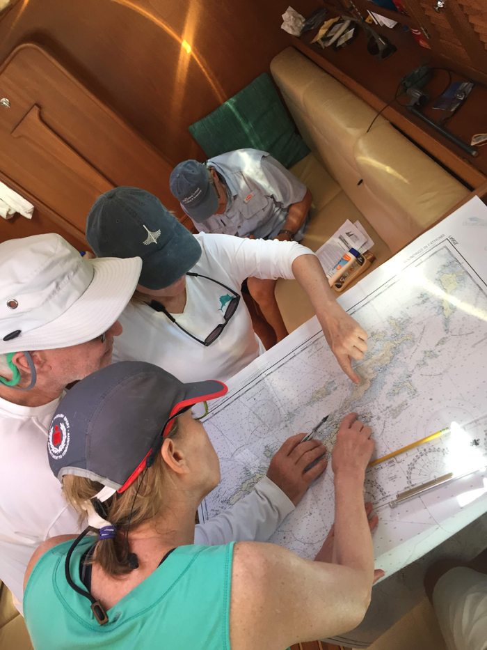
Each student crew will now act as skipper for one full day, with Rick starting the rotation. But first we spend time unlocking the “navigational chart mysteries” (NOAA Chart #1 is most helpful here) and getting to know such critical resources as the US Coast Pilot 5 and local Cruising Guides. Having a good navigation plan in hand gives us great peace of mind when a strong, sustained squall moves through as we head to British VI waters for points-of-sail practice. Ann, who is doing a great job learning to steer a large boat, has the good sense to hand the helm to the captain as visibility becomes near zero and we turn on running lights and double our lookouts. While monitoring our progress, the “danger depth” of 60 feet will keep us off Rata Cay to our south and Carvel Rock to the north. Harvey, using his hand-held Garmin 76, confirms that we are where we should be. Not to be outdone, Rick has been tracking our progress with his small Garmin GPS on his wrist. He has sent all of us the attached link (see https://connect.garmin.com/modern/activity/3345909976), and zooming in on our track we can follow the boat’s multiple circles and turns where we have practiced picking up moorings or MOB recovery. For the night, we moor in Caneel Bay. From there, and during our dinghy run into Cruz Bay for a dinner ashore, we replicate following certain latitude/longitude lines on a hand bearing compass plus Harvey’s GPS to safely return to our boat in full dark.
Day 3—Caneel Bay to Leinster Bay via Francis Bay and Fungi Passage
Still secure at our mooring, three students take the ASA101 test (all pass with flying colors) while the captain covers engineering plus advanced navigation topics with Denny and Rick who need to be familiar with them if they want to charter in the future. That includes a close look at the U.S. Coast Guard Light List Vol III and how to make effective use of the wealth of information it provides to all mariners. Students are a little surprised when they learn that the Local Notices to Mariners, when checked against the Light List, tells us that recent weather events had effected 3 of the 5 buoys surrounding nearby Johnson Reef (LL item #32680) -- with one having been pushed off station (See lnm07052019, p. 16.) We discuss hazard analysis as we motor through the Derloe Channel past Johnson Reef and then sail to Francis Bay where, on a mooring, we have lunch and practice knots. Once clear of Fungi Passage, we sail upwind to Leinster Bay where we pay our mooring fees for several nights. Once again moored, some of us snorkel in the company of sea turtles and a stingray while others explore the nearby ruins of a sugar mill.
Day 4—Rounding St. John: Leinster Bay to Salt Pond Bay via Sir Francis Drake Passage
All take turns tacking north along Sir Francis Drake Passage in headwinds at 18+ knots and with all three sails set. Initially, with a counter current running at 3 knots, we add the engine. The crew had developed a three-leg nav plan around St. John to the beginning of Flanagan Passage. From here, they had drawn a course we use as a danger bearing off Ram Head to keep us well south of a hidden danger: Eagle Shoal. Rick and Denny are now repeatedly confirming our safe progress by using the “Go To” function on the captain's Garmin and entering their electronic fixes on our chart. Next, having established a waypoint off Booby Rock at Salt Pond Bay entrance, we slowly motor past the reef and to a mooring at this most idyllic spot. Before dinner, there is time for more snorkeling amid more sea turtles and other marine life.
Day 5—Salt Pond Bay around Frenchcap Cay to St. James Bay
Right after breakfast, students complete the ASA103 test before we sail southwest into the Caribbean Sea. Nancy, Harvey and Ann have developed a three-leg nav plan around French Cap Cay just visible over the horizon. Also today, Rick and Denny start navigating at that advanced level that distance cruisers will want to master: Dead Reckoning (DR) plus compass conversion and plotting in relation to True North. All route planning—already long done in the ship’s log—is now plotted using True North. They add DR marks using an estimated speed of five knots. A sample for leg # 1 looks something like this:
Rhumb
Line:
Booby Rock to St. James Bay. Chart 25641—Virgin
Islands
Leg 1: Booby Rock to
southeast of French Cap Cay
Wpt # 1: Booby Rock
|
T
|
V
|
M
|
D
|
C
|
|
232
|
14W
|
246
|
0
|
246
|
Course plotted is
232ºT =
246ºpsc (per ship’s compass) to steer to reach the next waypoint.
When we reach St. James Bay in late afternoon, all moorings have already been taken. We drop anchor in sand (to avoid coral damage) and snorkel looking for, and finding, more marine life.
Day 6—St. James Bay to St. Thomas Harbor and Cay Bay
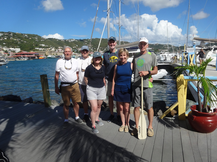
The navigational challenge today is to approach and enter St. Thomas Harbor by locating and lining up the Berg Hill Front and Rear Range Lights we had discussed in our online meeting and identified as Light List items 32580 and 32575). Once lined up, they were guiding us - as well as a huge cruise ship - on a range of 344ºTrue (358ºpsc) safely into the harbor that is marked by reefs on either side. Once in Cay Bay, we pick up a mooring and pile into the dinghy to have a late lunch for two reasons: to enjoy each other’s company one more time and say good bye to Ann and Rick who have to catch a plane in response to a family emergency back home. We assemble for one more photo and help them into a taxi (Bon Voyage, friends!) before Denny and the captain dinghy back to the boat for Denny’s ASA104 test. A pleasant dinner ashore at a local seafood restaurant rounds out our day in this busy, storied seaport.
|

|
Click image to enlarge |
Day 7—St. Thomas Harbor to Christmas Cove
As we depart our mooring - Nancy competently steering the boat - we watch for descending sea planes from St. Croix that land intermittently right next to our mooring field as described in the 2018 U.S. Coast Pilot 5, Chapter 14, p. 546 . We motor until we are able to use the range lights on Berg Hill as an “aft range” to navigate safely at 178ºpsc past huge, moored cruise ships and then out of the harbor. The crew has decided on a nav plan that takes us south of Buck and Capella Islands and then ENE upwind under full main and stay sail (we are saving our jib which developed a small tear) to Christmas Cove. All moorings having been taken, we drop anchor and swim or snorkel to cool off before our final dinner together on board.
 |
Click image to enlarge |
Day 8-- Christmas Cove to Red Hook Bay
We rise early, have breakfast of hot oatmeal and coffee and weigh anchor for our final leg past Current Rock. We had discussed Current Rock in our online meeting, pointing out that it is featured in the MDSchool you Tube Video Buoys and Beacons. We find that the 20 foot tower supporting Current Rock Light, FL W 6s, together with its red and white Day Board (LL # 32470) had been toppled by Hurricane Irma. The Local Notice to Mariners 7 had given us this relevant information and alert. On we motor to Red Hook Inlet. We hail the fuel dock on VHF Ch 16 where Skip King takes our lines to top off our fuel tank. We make it into our slip, clean the boat and offload our gear. We bid each other a fond farewell with big smiles and future sailing adventures in mind.
Well done, shipmates. Your captain thanks you--with best wishes for your cruising life ahead.
Captain H. Jochen Hoffmann
Maryland School of Sailing and Seamanship
On board S/V GRATEFUL DAD
Red Hook, USVI, February, 2019