|
|
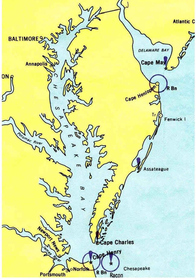
2020 DELMARVA Reports |
Home
|
I boarded our sailing vessel NAVIGATOR on
Sunday, October 4, 2020 while she lay at dock at Lankford Bay Marina, Rock Hall,
MD. This allowed me a few days to inspect and prep the boat and lay in food
provisions for the forthcoming DELMARVA circumnavigation cruise before Captain
Jerry Nigro, my Mate for this cruise, was due to arrive on Thursday. During a
previous cruise in July, NAVIGATOR was struck by lightening, which
blew out all of her electronics and much of her electrical equipment and wiring,
and she underwent a two-month repair period at Haven Harbour Marina where all
the damage was repaired. Immediately upon completion of this work, NAVIGATOR
completed two DELMARVA circumnavigation cruises in September, one with Captain
Steve Runals and the other with Captain Frank Mummert. Thus, early October was
my first opportunity to spend some time onboard and become familiar with the
newly installed equipment, which I did with pleasure since everything seemed to
work perfectly... a good omen for the forthcoming cruise. Jerry arrived on Thursday as planned and proceeded
to refamiliarize himself with the boat, on which he has sailed several offshore
cruises, and the newly installed equipment. Jerry and I have sailed together on
many ocean cruises over the past 20 years, on my boats as well as his. Jerry
owns a Skye 51 foot cutter rig on which he completed an Atlantic Circle cruise
New York-Bermuda-Azores-Portugal-Madeira-St Thomas-Florida-Bermuda-New York in
2015. I sailed several of these legs with Jerry, and the last two legs also
included MDSchool students. Two weeks prior, we held an online meeting with all
crewmembers for this DMVA cruise plus Rita who gave a run down on administrative
matters and Covid procedures. Student sailors in attendance were: Michael Acker,
Johan Liljeros and JP Sarmiento; we usually carry four students for this cruise,
but in deference to the Covid, we limited it to to three students. I then
reviewed our plans for the cruise including the itinerary per the DMVA Training
Plan, cruise route per the charts, pre-cruise assignments, preparation
guidelines, mainsail single line reefing diagram, and the meal plan. The DMVA
cruise involves a great deal of meticulous coastal navigation in a variety of
conditions and venues. To help prepare for this, I made the following
assignments to be completed prior to the cruise:
·
JP- Lookup current forecasts for the C&D
Canal, Delaware River at Reedy Point and the Cape Charles Bridge; identify any
Dredges operating along our route. · All- Review the Training Plan provided including all videos listed there plus the new video Navigation Preparations for an Advanced Coastal Cruise
Then, on Friday afternoon October 9th, our three
student sailors arrived onboard, stowed their personal gear and we proceeded to
inspect NAVIGATOR below deck from bow to stern including all
stowage areas plus the electronics, emergency gear, galley, engine, tools, spare
parts, logbook setup and charts. After this we went to Harbour Shack Restaurant
for dinner and a relaxed evening where we could tell sea stories and get to know
each other. Our three students had earlier decided to sleep ashore at hotels
during the preparation phase of this cruise to ensure a good night's sleep in
advance of the cruise, and Jerry and I returned to NAVIGATOR. On Saturday we conducted onboard in-port training
per the DMVA Training Plan, a 168 page document, that we wrote to describe the
important actions and procedures needed to complete this 450 mile cruise around
the DELMARVA Peninsula; quoting from the Introduction to this book: Team building is the clear
and over-arching focus of this training, as the smooth functioning of a vessel's
crew as a team is essential to the safe and happy completion of an advanced
coastal cruise in daylight and nighttime operations in all sorts of weather
conditions. Specific activities are
listed and detailed, which student crew need to learn and carryout under actual
operating conditions. Many of the specifics given below are based on the
configurations as currently exist on S/V NAVIGATOR, IP40. As you sail on
other boats with different equipment configurations, you will of course need to
make adjustments in some of these procedures. Following the checklists of the Training Plan, we inspected
all deck equipment and rigging, raised and reefed all sails, rigged the main
boom preventer line, deployed the whisker pole, practiced engine starting and
stopping procedures, tried on the Type I PFDs, coiled and tossed docklines and
throw rope, deployed the MOB horseshoe and pole, noted the locations of all five
onboard fire extinguishers, reviewed the cockpit electronics, and completed the
remaining items in the checklists. I then assigned crewmembers to complete the
specific checklists for Navigator, Bos'n, Engineer and Emergency Coordinator and
followed that with a review of weather and preparation of our underway
navigation plan for the next day's transit to Swan Creek for an overnight
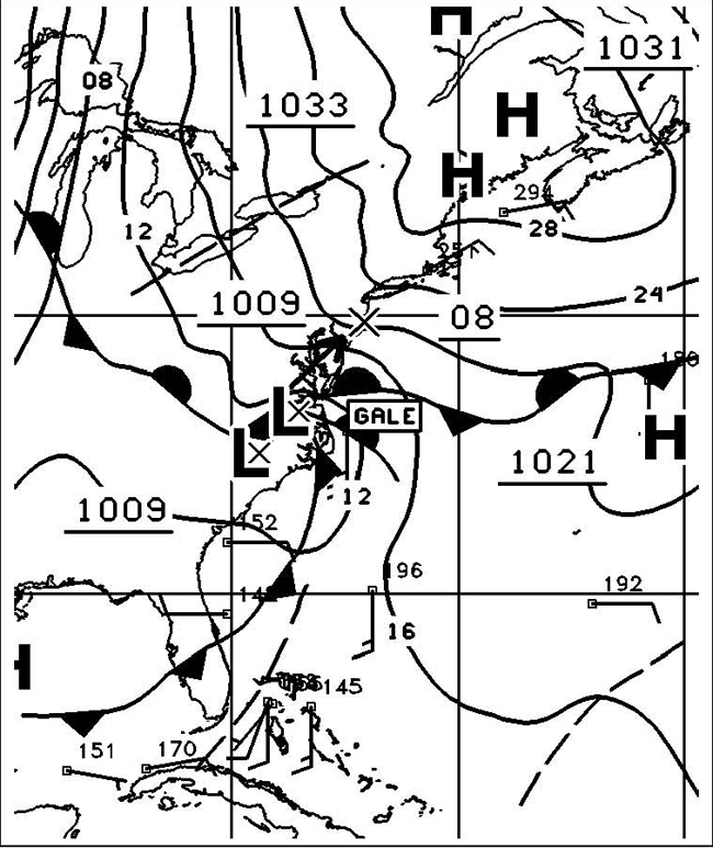
anchorage. At this point on Saturday, the weather forecast looked a bit
challenging for Monday, the day we plan to proceed north up Chesapeake Bay, with
expected winds of 20 to 30 knots from the north... right on our nose! On Sunday, the weather dawned clear and calm, but the forecast for tomorrow remained 20 to 30 knots from the north, so we made a last minute change in plans to proceed from our Lankford Bay Marina in Rock Hall directly to the C&D Canal about 50 miles to the north up Chesapeake Bay with no stops along the way. Crew went through the "Day of Departure" checklist in the Training Plan and we were underway at 0840 for the ten hour trek to the C&D Canal. Yesterday we had prepared our navigation plan only for the cruise leg to Swan Creek, so Johan and JP worked on the additional navigation planning needed to reach the Canal while Mike and Jerry stood watch underway until the additional nav prep was completed. There was very little wind movement this day, so we motored all the way to the Canal reaching the Summit North Marina at 1800 hours where we docked on a T-head floating dock, secured the boat and went to the Grain Restaurant for dinner and showers. Then lights out by 10:00 pm with the plan to remain in port tomorrow while the forecast storm passes.
By Monday morning the storm clouds had in fact
gathered and gale-force winds were beginning to howl, so after breakfast we
moved to the fuel dock to top up our diesel tank and pumpout the waste holding
tank and returned to our T-head dock. This will be a down day in port that we
will make good use of by preparing the navigation plan from here on the C&D
Canal, down Delaware Bay, south along the Atlantic Coast of Delaware, Maryland
and Virginia to the entrance of Chesapeake Bay at Cape Charles, and north up
Chesapeake Bay for several miles to Cape Charles Town where we plan to
overnight. The crew got busy with this sizeable task following the guidance
provided in the Training Plan and our recently published YouTube video titled: Navigation
Preparations for an Advanced Coastal Cruise. The crew worked as a team, all participating in the
activity, so that everyone knew the details of the route to be sailed,
waypoints, course directions and distances, Light List and Notices to Mariners
references, and the electronic course plotter as well as the paper charts. After
this the student crew wrote their ASA106 exam, which I reviewed and
graded after the cruise. By this time it was late afternoon, and we all again
went to the Grain Restaurant for an early dinner as we plan to be up and
underway bright and early tomorrow morning. By Tuesday morning the weather had moderated and
mostly cleared as we exited the marina at 0700, entered the Canal and turned
left, eastward and passed under the Conrail bridge, which was in the up position
so there was no need to contact the bridge tender. Sailing is not permitted in
the C&D Canal, so we set the engine speed to 2400 rpm and moved along
briskly down the flat waters of the canal. We knew that the Delaware River
current at Reedy Point, where we would exit the canal into river, was ebbing and
thus flowing outbound toward our right. We would thus be making a full turn to
starboard as we entered the strong current of the river and needed to make this
turn at the appropriate spot to ensure that we avoided the rock jetty extending
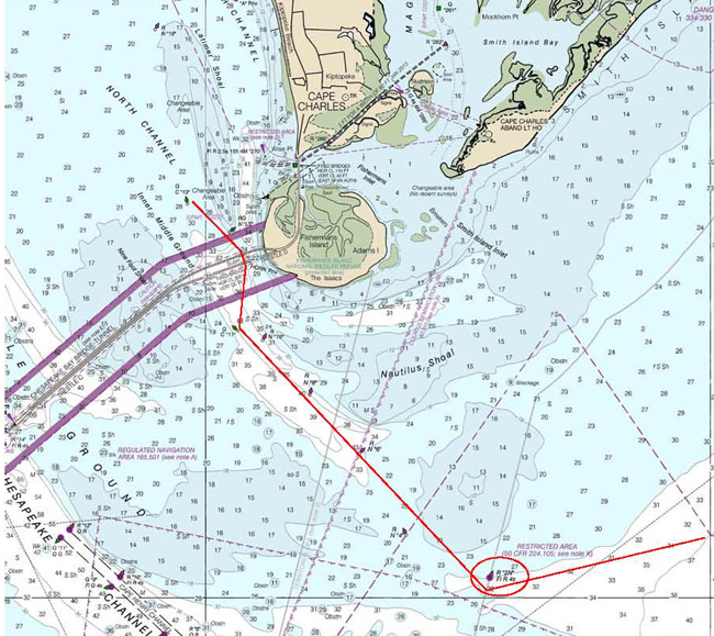
out from the canal on our starboard side. We accomplished this by pre-planning
our turn to be made when abeam of the red over green buoy (RG "CD"
Fl(2+1) R 6s) to our port side. Since we were on a course of 092ºC in the
canal, we verified this turning point when the buoy bore 002ºC on our port side
and double checked this with visual confirmation that we had in fact passed the
end of the jetty. We then turned SE to a course of 152ºC toward the green
buoy (G"11" QG) of the main ship channel. As we proceed down the
river, our plan is to remain on the west side of the main channel leaving the
green NavAids close aboard to our port side. We generally think of Delaware Bay
as a "nasty bay" with lots of shoaling, strong currents, fast-moving
big ships and lots of other traffic. So we need to pay close attention to our
navigation and watch keeping, and we set the watches as follows:
Current in Delaware Bay and River varies between two knots
Flood and two knots Ebb and can thus have a significant impact on transit times
down the Bay. Of course, traveling at a 6 knot water speed over a distance of 60
miles will expose us to both max Flood and max Ebb currents, but it would be
helpful to have more Ebb than Flood when traveling south from the C&D Canal
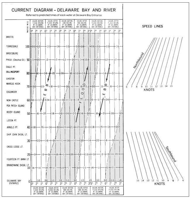
to Cape Henlopen. The NOAA Current Tables include a simple graph to help
mariners estimate the optimum time to make this passage on any given day.
Notice the lefthand column of geographic names starting
from Delaware Bay Entrance at zero miles at the bottom and Bristol at 100+ miles
at the top. Across the bottom is a series of time legends correlated to times in
the current cycle starting with "Hours before Flood Begins at Delaware Bay
Entrance" on the lefthand side. On this legend the current would be Slack
at Delaware Bay Entrance at zero hours before Flood begins. The main body of
this graph shows Flood and Ebb areas correlated with these time and geographic
names. Proper setup of this graph for our date and time of entering the bay will
allow us to estimate the currents to be expected during our transit down the
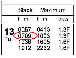
bay. On this date of Tuesday, October 13, 2020 we passed Reedy
Island at 0900 EDT or 0800 EST. The NOAA Current Tables for this date show that
Slack before Flood at Delaware Bay Entrance occurred at 0709 EST, so we passed
Reedy Island about one hour after Flood began at Delaware Bay Entrance.
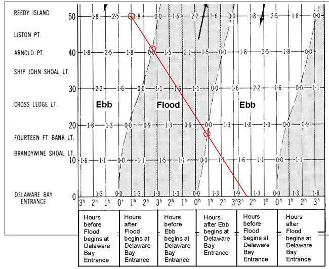
Our boat speed through the water was 5.5 knots heading south. We can plot a speed line on the previous graph starting at Reedy Island at one hour after Flood began at Delaware Bay Entrance, and from there draw a 5.5 knot Speed Line as shown in red in the graph as above. This shows that we can expect Ebb current between Reedy Island and Arnold Point. Current then turns to Flood, or opposed to us, until we pass Fourteen Foot Bank Light where it Ebbs for the remainder of the distance to Delaware Bay Entrance. Tuesday at 1040: Motor sailing down Liston Range
with mainsail on a broad reach in 10 to 12 knot wind from NW; skies overcast
with stratocumulus clouds; waves two feet or less; approaching Ship John Shoal
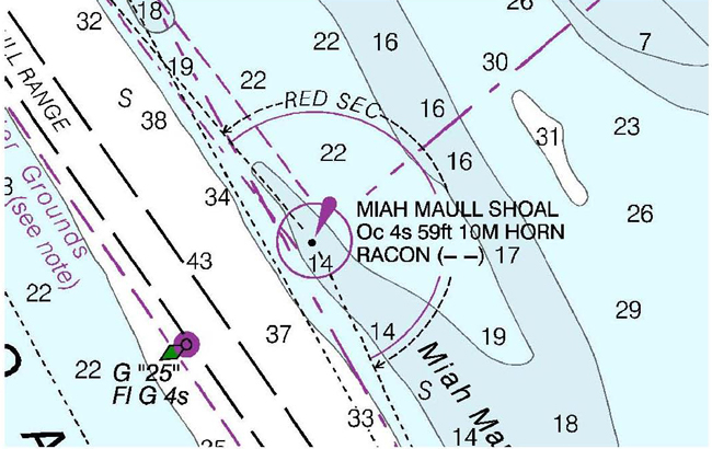
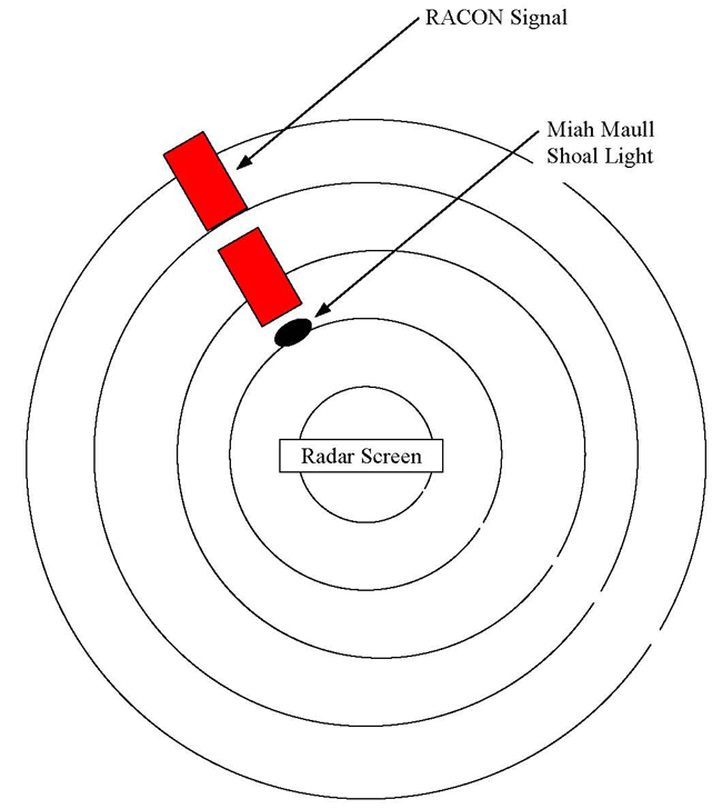
Light. At 1230 we saw the Racon signal of Miah Maul Shoal Light on our radar
screen flashing Dash-Dash. A Racon is an electronic device that responds to our
radar signal and paints a Morse Code sequence on our radar screen for positive
identification. Chart #12304 shows this Racon and its Morse Code sequence (- -)
as below:
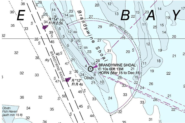
At 1400 we passed Brandywine Shoal Light; skies clouded
over; cooler as late afternoon approaches; current slack as expected from our
previous analysis; speed through water 5.5 knots; speed over ground 5.5 knots.
At 1500 passed Brown Shoal Light. Reefed mainsail one tuck
in preparation for forecast wind increase overnight; expecting NW 15 to 20 knots
with gusts to 25 knots. Unfurled full genoa; secured engine. Sailing 5.5 knots
through the water; speed over ground 5.5 knots. Brown Shoal Light marks the
southern end of the Delaware Bay Main Channel. From here the deep water widens
out to the mouth of the bay, and we set a course for Cape Henlopen requiring a
20 degree course change to starboard and improving our apparent wind angle
enough to permit full sail on a broad reach starboard tack. At 1640 we passed
the green G "5" Fl G 2.5s buoy, leaving it to starboard, which marks
the western corner of the Pilot Area where ship pilots meet incoming and
departing ships. We steered clear of the Pilot area leaving it to our port side
as we proceeded south between the coast and the outbound traffic lane where
outbound ships are making fast for sea usually at 18 to 20 knots.
At 1700, after rounding Cape Henlopen on starboard tack and
turning to a course of 180º per compass to remain between the traffic lanes and
the coastline, the winds became dead astern making for poor sailing conditions,
and we doused the genoa and started engine. Eventhough winds remained at NNW 20
knots, we were unable to effectively sail on this course as we were trapped
between the traffic lanes and the coastline with decreasing depths thus
preventing us from heading up to improve apparent wind angle. So we motor sailed
on while Johan prepared a delicious dinner of pasta and meatballs with fresh
green peppers as a side. By 1900 a cold front passed our location, skies cleared,
stars came out, winds backed to WNW and we were able to unfurl the genoa and
secure the engine for a beautiful nighttime sail on a course of 200ºC in 20 to
25 knot winds, gusting to 30 knots. It was fascinating to actually see
this cold front come through from the west. Initially, skies were completely
clouded over. Then we saw a slight crack of bright sky to the western horizon
where the sun was setting over the land. This crack grew in height over the next
hour and eventually spread overhead and moved to our east leaving a pitch black
sky with billions of stars and a cooling WNW breeze that freed up our sails for
better speed and control. By 2300 we reached the intermediate red sea buoy R
"6" Fl R 6s off of Chincoteague where we changed course to 220ºC to
follow the coastline which is now bending away to the west thus bringing the
apparent wind forward and again improving sailing performance. Beautiful sailing
conditions with clear skies, bright stars, brisk cool air and a very nice boat
motion!
By 0200 on Wednesday morning, with consistent NW 25
knot winds gusting to 30 knots, we reduced the genoa to one-third keeping the
mainsail with one reef tuck. At 0300 crescent moon rising in the eastern sky. At
0500 wind clocked to North at 25 knots. At 0700 Sun up; winds down to 15 to 20
knots NNE; increased genoa to three-quarters out. Sparkling, clear day. At 0715
engine turned on for battery charging for one hour. Solar panel producing 7.0
amps on this bright, sunny morning.
Winds dropped to 12 to 15 knots NNE; bright clear day;
deployed full mainsail and genoa. At 1200 passed the red sea buoy R
"14" Fl R 2.5s east of Cape Charles; sailing 5.0 knots water speed.
Changed course to 246ºC toward the R "2N" Fl R 4s buoy at the
northern entrance to Chesapeake Bay. At 1300 wind dropped to 5 knots; furled genoa; strapped
mainsail in tight; started engine at 2400 rpm on a course to R "2N"
buoy 9 miles distant, which we passed at 1430 turning NW up the Nautilus Shoal
Channel toward the bridge span and passing through the bridge at 1600. We then
set a course 356ºC for Cape Charles about ten miles distant. Weather forecast for today, tonight and tomorrow is
favorable for the trip up the bay to Annapolis, but by Friday the forecast is
for 20 knot winds from the North plus rain and limited visibility, not good or
an overnight cruise up Chesapeake Bay with the normally many commercial ships
underway. Johan suggested that, in view of the weather forecast for the next two
days, we consider continuing non-stop direct to Annapolis. Mike readily agreed,
and it sounded like a good plan to me, so it was agreed that we would continue
on north now, and decide at the time whether to go into Annapolis or continue
straight through to home port at Lankford Bay Marina. JP and Johan developed the
navigation plan for the remainder of the cruise up the bay to Rock Hall. At this point, I changed the watch schedule, switching JR
and Mike, all else remaining the same, as follows:
The overnight passage up the bay went well with pleasant,
cool weather; clear skies, winds building to 15 to 20 knots from the south which
was just great for our trip north. We kept the mainsail single reefed and used
the genoa variously as the wind angle permitted. Met a number of ships
overnight, traveling both north and south, but these were handled well by the
watchkeepers who were now experienced with night sailing and use of the radar,
AIS, VHF radio, charts and their eyes for spotting ships as well as buoys and
potential obstructions. By Thursday morning, we decided to skip Annapolis and go directly to Rock Hall today in view of the expected adverse weather for Friday. Passing under the Annapolis Bay Bridge, we turned NE toward Love Point at the north end of Kent Island bringing the apparent wind forward to a good broad-reaching angle on starboard tack, and NAVIGATOR charged ahead with renewed energy. Approaching Love Point we turned further east to begin rounding Love Point marker on an exhilarating beam reach. The crew clicked perfectly, as a well-oiled team, expertly doing their assigned duties as helmsman, line handlers, lookout and navigator to thread between the many fishing boats and passing yachts while achieving quality sail trim and maximum boat speed. Passing Love Point rocks, we headed up further on the wind to close-hauled and roared ahead at eight knots. It took a few tacks, well executed, to reach the horseshoe river bend where we bore away to the east for a mile then gybed, executing a perfect PST-TSP gybe per the Training Plan, and headed north toward Langford Creek and home.
Once past the R "14" red buoy, we paused to
conduct some MOB drills using Weenie, our MOB manikin as the overboard victim. I
threw Weenie overboard, and, with each student taking a turn at the helm, we did
a quick stop tack and back, furled the genoa, dropped the mainsail and motored
close to the victim for a pickup with the boat hook. This illustrated the
principles of quickly stopping and using engine power for maneuvering for the
pickup. All went pretty smoothly. Speed
Calibration During the entire cruise of the past week, the boat speed
instrument (Garmin UDST) seemed to be reading high. The
speed sensor mounted through the hull underwater measures speed of the water
passing by, interprets this as boat speed through the water, and the electronics
display this as boat speed in nautical miles per hour or knots. So we decided to
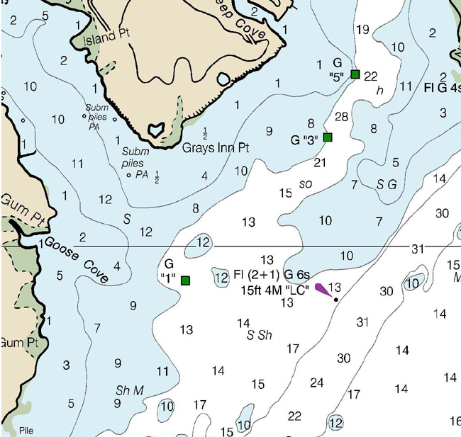
make a speed calibration run in Chester River between green dayboard
G"1" and the green over red channel junction light Fl (2+1) G 6s 15ft
4M "LC". The measured distance between these beacons is 0.60 NM, and
the bearing in one direction is 096ºT (107ºC) and the reciprocal is 276ºT
(284ºC). This course is at roughly right angles to the current flow. Outbound
leg was from "LC" west to G "1" and Return leg was from G
"1" to "LC". We ran between these beacons at 2400 engine rpm giving us
an indicated boat speed of 7.6 knots for the Outbound leg, and 7.2 knots for the
Return leg. I was at the helm; Johan and Mike marked elapsed time for each run;
JP was lookout for other traffic, and Jerry called out to me to come right or
come left to stay on track to the destination mark as my eyes were paying close
attention to the compass course and the boat speed fluctuations in order to
mentally average the indicated speed. Indicated boat speed through the water Outbound, SIO
= 7.6 knots Indicated boat speed through the water Return, SIR
= 7.2 knots Average Speed Factor, SF = (SFO + SFR)
÷ 2 = (0.85 + 0.86) ÷ 2 = 0.855 In the future, calculate corrected boat speed through the
water, SC = 0.855 x SI (speed through the water indicated
by the Garmin UDST instrument.) This is not GPS speed. And, since distance traveled in a given time period equals
speed divided by time, and since both are based on the same sensor in contact
with the water, the calibration factors for both speed and distance are
numerically equal: Distance Factor, DF = SF = 0.855 In the future, calculate corrected distance traveled
through the water, DC = 0.855 x DI (distance through the
water indicated by instrument.) This is not GPS distance.
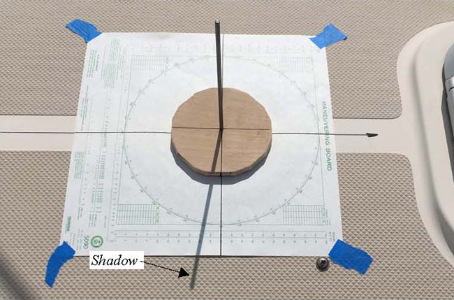
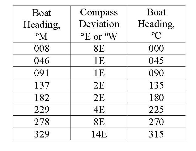
Also, we calibrated the steering compass using shadows cast by the Sun for reference as outlined in the Training Plan page D-3. This is the easiest, simplest and most accurate method for calibrating a compass. Bearings to the Sun were measured using a simple sundial built from a 4 inch diameter piece of wood with a 1/8th inch diameter metal rod standing squarely in the middle; dark centerlines were drawn at right angles to each other as shown below. This sundial was placed in the center of a 360º paper compass rose taped to the foredeck of the boat, thus allowing the Sun to cast a shadow of the sundial pin onto the compass rose and thereby provide a direct measurement of the Sun's direction relative to the bow of the boat. In
this photograph, the sun dial appears to be off center from the compass rose,
but this appearance results from the side perspective of the photo... The sun
dial is actually squarely in the center of the compass rose when viewed from
directly above.
A Radar Maneuvering Board paper
chart was used for the 360º compass rose. A dark line was drawn along the 0º
to 180º axis and a second dark line along the 90º to 270º axis. We taped this
compass rose to the foredeck of the boat with 0º toward the bow and 180º
toward the stern and the 0º to 180º axis aligned with the boat fore and aft
centerline. This was then used to measure angles relative to the bow of
the boat. The boat was headed in eight different directions around an
octagonal course. Each boat heading was read directly from the steering compass,
and the shadow cast by the Sun was marked on the compass rose chart shown above.
Time was recorded at the moment of marking the shadow to enable calculation of
the True direction to the Sun as follows:
Date: October 15, 2020 Calibration results are shown in the three tables below.
These results are considerably different than the previous Deviation Table, which may be due to the extensive electrical repairs completed in August after the lightening strike. We will redo this calibration in the future to verify.
As outlined in the
Training Plan, we made entries into the Deck Logbook during the cruise to record
essential information including:
o
Course steered during the
previous hour o
Distance odometer reading o
Wind direction & speed o
Wave direction and height o
Barometer o
Sea water temperature o
Cloud coverage percentage
and type o
Battery voltages o
Bilge water level and
pumpout time o
Initials for completed
boat inspection per checklist o
DR calculations for
distance and course steered Since this advanced
coastal cruise is, among other things, intended as a stepping-stone experience
for sailors planning to make blue water ocean passages, the Training Plan
requires students to plot a Dead Reckoning course similar to what is done
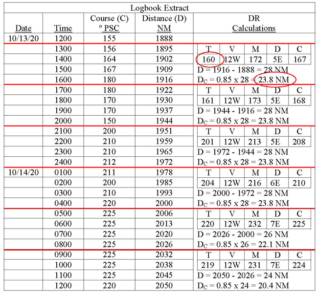
offshore in conjunction with celestial navigation. To accomplish this, Logbook data
starting at noon on October 13, between Elbow of Cross Ledge Range in Delaware Bay and Cape Charles
was reduced and plotted on an NGA #926 Position Plotting Sheet. Starting point
was 39º12.7'N and 075º17.6'W at buoy G "31" Fl G 2.5 seconds in
Cross Ledge Range of Delaware Bay. Following is an
extract from our Deck Log hourly data during the cruise from noon on Oct 13 to
noon on Oct 14. The first four columns are entered by the Helmsman at completion
of each one-hour watch trick; the last column is used for the DR calculations as
follows: ·
Courses will be plotted in
True degrees, so it was necessary to convert the Compass courses to Magnetic and
then to True degrees as shown in the TVMDC tables. Magnetic Variation was taken
from the compass roses on Charts 12304 and 12200, updated to the current year
and rounded to a whole number of degrees. Compass deviation was looked up in the
boat's Deviation Table shown in the Training Plan. · Distances were calculated for each 4-hour period by subtracting one log reading from the log reading four hours later. For example, for the interval from 1200 to 1600, D = 1916 - 1888 = 28 NM, and the corrected distance, DC = 0.85 x 28 = 23.8 NM using the distance correction factor determined recently as described above.
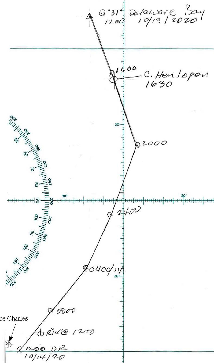
Resulting
DR was then plotted as shown below. It shows good correlation between the DR
results after 24 hours of sailing when we arrived a red buoy R "2N"
off Cape Charles, using only the steering compass and the distance log for the
DR. I generally find good correlation between the DR and actual position if the
Logbook entries and faithfully and consistently made by the crew. I call them my
collection of compensating errors and have seen similar good correlation over
years of sailing offshore. On an ocean passage, this DR plot will then be used
in conjunction with celestial lines of position (LOPs) to carryout an ocean
navigation process using these classical techniques.
Arrival We
arrived back at home port Lankford Bay Marina around 1600 on Thursday, October
15th after completing this 450 mile circumnavigation of the DMVA Peninsula in
four and a half days with one stop along the way. We had some excellent sailing
weather, and prudently avoided the two gales that Mother Nature threw in our way
on Monday and Friday by amending our sailing schedule to suit. An important
principle of advanced coastal sailing, any sailing, is to avoid bad weather if
possible by altering schedules. My crew: Mike, JP, Johan, and Mate Jerry were
wonderful to be with on this really exciting cruise. They were all-in with the
learning experience and served very well as good shipmates with enthusiasm and
good cheer. Fair
Winds! Captain
Tom Tursi
|
||||||||||||||||||||||||||||||||||||||||||||||||||||||||||||||||||
Web site design by F. Hayden Designs, Inc.