| Course: |
Advanced Coastal Cruising; DELMARVA Circumnavigation |
| Date: |
July 15-23, 2022 |
| Vessel: |
S/V NAVIGATOR, IP40
|
| Students: |
Alan
Clarke, Fred Demuynck, Tom Haldis, and Albert Wichmann |
| Mate |
Rita Hanson |
| Captain |
Tom Tursi |
7/15
Friday afternoon, student crew arrived: Alan Clarke, Fred Demuynck, Tom Haldis,
and Albert Wichmann and First Mate Rita Hanson; conducted below deck inspection
per the training plan; out to dinner at Harbor Shack.
7/16
Saturday conducted on-deck inspection, deployed sails including whisker pole and
prepared navigation for tomorrow's trip to Swan Creek; weather looks good but
hot; out to dinner at Baywolf.
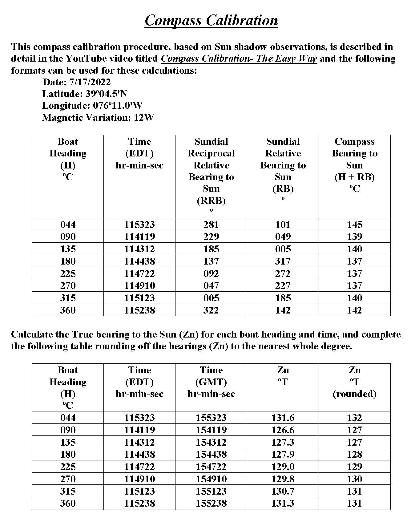
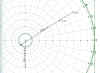
7/17
Sunday up early; underway by 0830; did compass calibration and speedo
calibration; see images of results below.
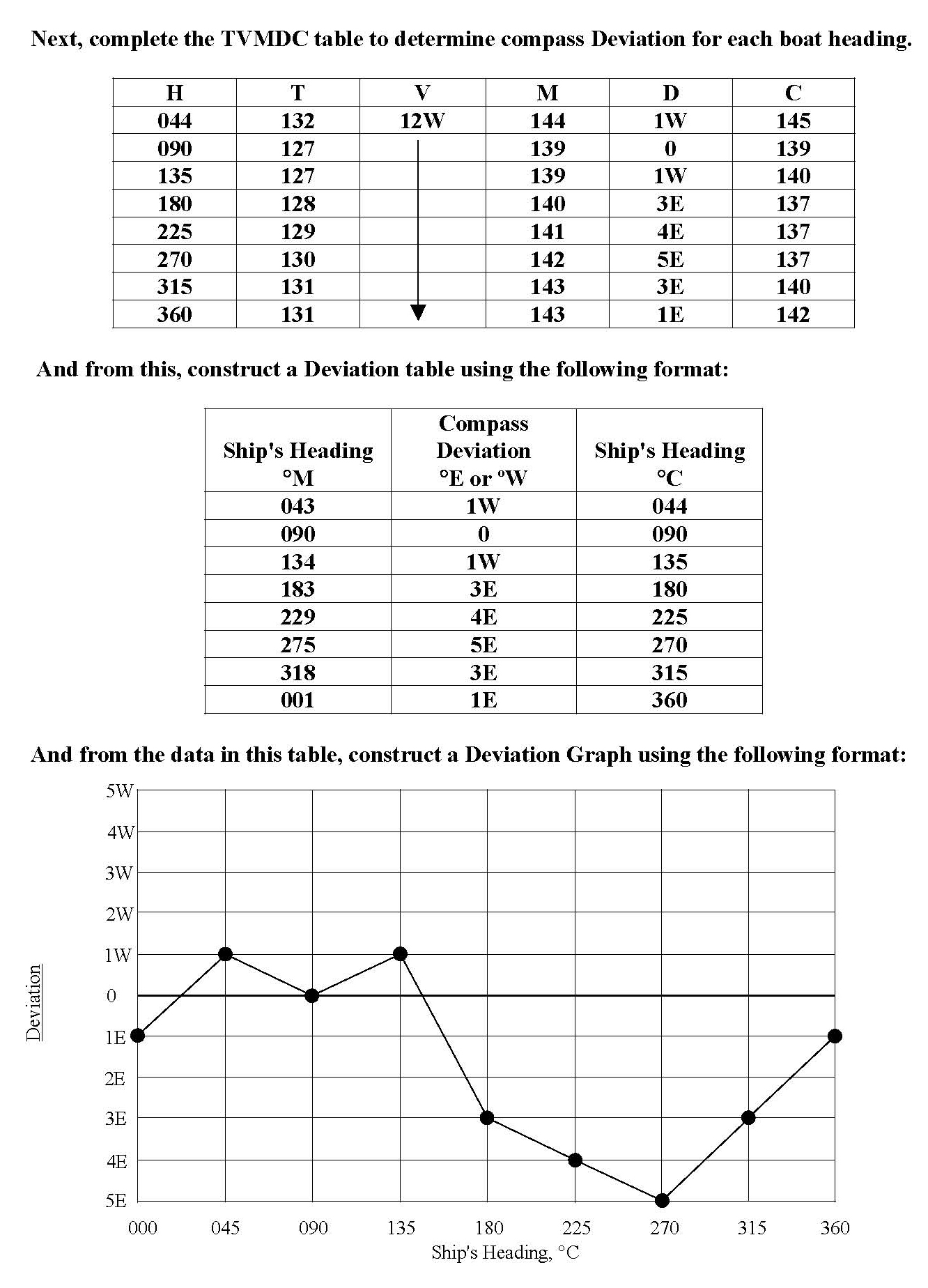
Speed
Calibration
A
speed calibration run was made in Chester River between green dayboard
G"1" and the green over red channel junction light Fl (2+1) G 6s 15ft
4M "LC". The measured distance on the chart between these beacons is
0.60 NM, and the bearing in one direction is 096ºT (107ºC) and the reciprocal
is 276ºT (284ºC). This course is at roughly right angles to the current flow.
Outbound leg was East from G "1" to "LC" and return leg was
"LC" to G "1".
 |
Click picture to enlarge |
We
ran between these beacons at 2400 engine rpm.
Indicated boat speed through the water Outbound, SIO =
7.2 knots
Elapsed time Outbound, TO =
0.0960 hour.
SOGO = 0.6 NM ÷
0.0960 hour = 6.250 knots
Speed Factor Outbound, SFO =
6.25 ÷ 7.2 = 0.868
Indicated
boat speed through the water Return, SIR =
7.0 knots
Elapsed time Return, TR =
0.0935 hour.
SOGR = 0.6 NM ÷
0.0935 hour = 6.417 knots
Speed Factor Return, SFR =
6.417 ÷ 7.0 = 0.917
Average
Speed Factor, SF = (SFO +
SFR) ÷ 2 = (0.868 + 0.917) ÷ 2 = 0.89
In
the future, calculate corrected boat speed through the water, SC =
0.89 x SI (speed
through the water indicated by the Garmin UDST instrument.) This is not GPS
speed.
And,
since distance traveled in a given time period equals speed divided by time, and
since both are based on the same sensor in contact with the water, the
calibration factors for both speed and distance are numerically equal:
Distance
Factor, DF = SF = 0.89
In
the future, calculate corrected distance traveled through the water, DC =
0.89 x DI (distance
through the water indicated by instrument.) This is not
GPS distance.
After
this, we conducted underway sail training;
motor sailed to Swan Creek; secured to mooring ball number two. Completed
navigation prep for tomorrow's cruise up the bay to C&D Canal. Dinner onboard
of beef stew.
7/18
Monday 0700 dropped mooring ball and motor sailed to C&D canal; students on
one-hour helm tricks; winds 15 to 18 from south; student practiced navigation
tasks including visual magnetic bearings and running fixes; arrived at Summit
North Marina by 1400; topped up fuel and pumped out; moored in a slip on dock I;
prepared navigation for trip down Delaware Bay and offshore Atlantic to Cape
Charles. Dinner at the Grain Restaurant. Watch schedule:
- Tom
H & Fred: 01 to 07; 13 to 19
- Albert
& Al: 07 to 13; 19 to 01
- Rita:
10 to 16; 22 to 04
- Tom
T: 04 to 10; 16 to 22
7/19
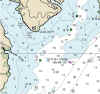
Tuesday underway 0730 for trip down Delaware bay; no winds; motored all the way
to Cape Henlopen. As we passed Brown Shoal Light, we noticed the Ferry Delaware
, several miles off to our portside on a crossing course. Fred took the
opportunity to draw a closest point of approach plot, as described in Appendix D
of the training plan, and concluded that the ferry would cross ahead of us by
less than 1/2 mile. A short time later the ferry hailed us over the VHF radio
and asked if we would "take our stern" to which we replied in the
affirmative. As the ferry approached on our portside, we bore left toward her
stern and had a safe and happy crossing.
 |
Ferry Crossing
Click to enlarge |
We continued motoring overnight and most of the next day Wednesday; last three hours winds came up for
a beautiful sail into Chesapeake Bay at Cape Charles; navigated to red N2 and up
channel to Fishermans Island bridge and to Cape Charles Town channel; Entered
Cape Charles Harbor in pitch black at 0100 Thursday; moored to a T-head dock.
7/21
Thursday noon departed slip and fueled and pumped out; left marina by 1300 for
beautiful sail up Chesapeake Bay during the afternoon and overnight in 12 to 15
knot southwest to west winds to Annapolis arriving there by 0900 Friday, 7/22; moored
in slip number 16; napped for an hour or two and three students took ASA106
written exam: Allen, Albert and Fred. Dinner at Pussers; ice cream along wharf
in Ego Alley. Completed navigation prep for tomorrow's trip to Rock Hall.
7/23
Saturday departed Annapolis 0730; weather sunny, hot and dry; motor-sailed to
Chester River; stopped at Deckleman's marina for pumpout and diesel; arrived at
Lankford Bay Marina 1300; moored in home slip; presented diplomas to students;
students departed by 1500.
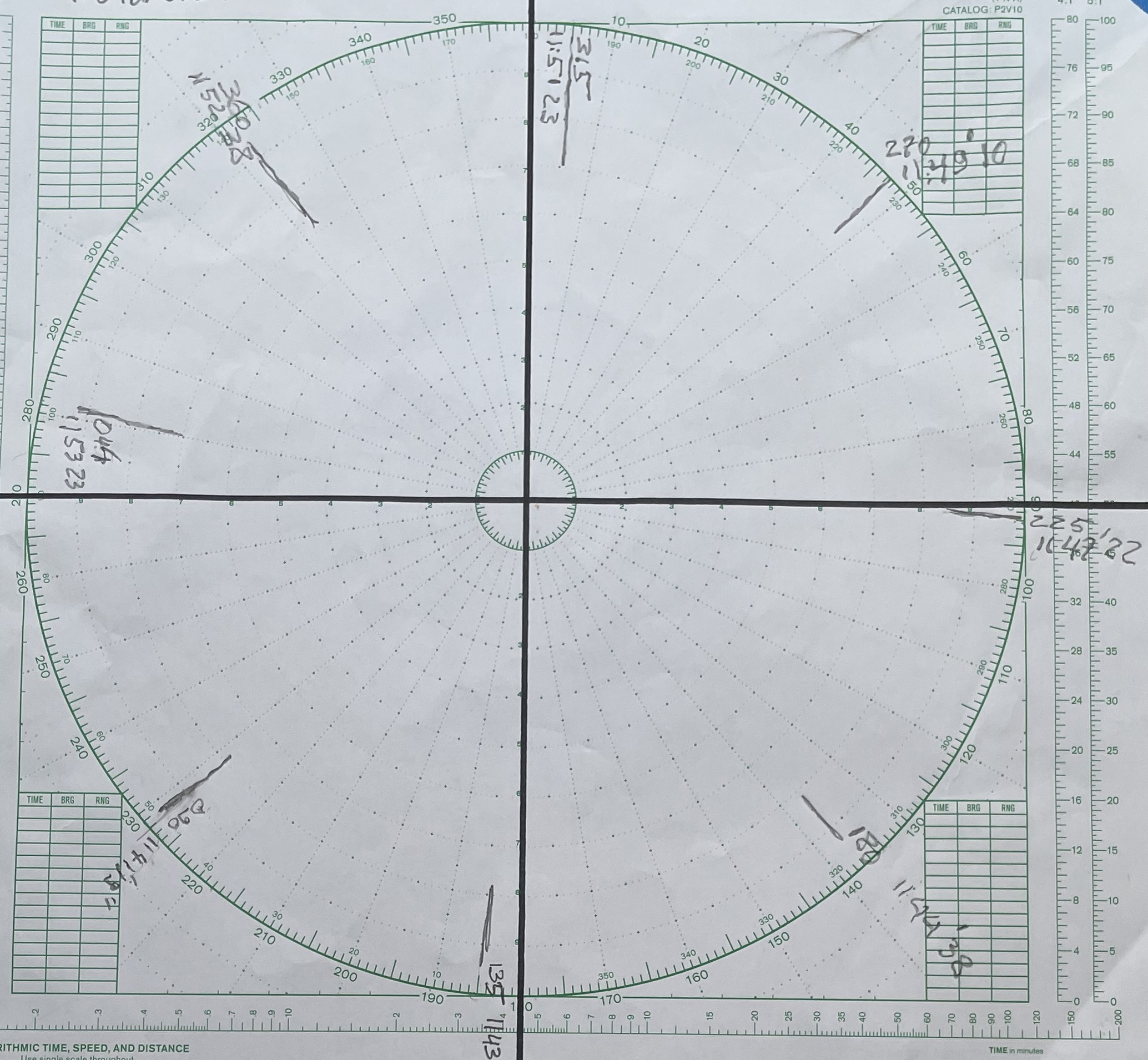
During
the cruise the student crew did hourly inspections of the boat and checked the
weather, navigation progress and ship traffic, and entered key information into
the Deck Logbook. Following is a DR Plot of the course and distance data based
on the ship's compass and distance log, which is very similar to the plot that
we keep during ocean cruises and used to facilitate celestial navigation plots.
|
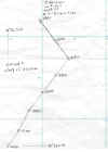
|
DR Plot
Click to enlarge |
Tom
Haldis put together an interesting Video of this cruise at https://youtu.be/A_ckiV1NxfI
Captain
Tom Tursi
S/V NAVIGATOR, IP40
Rock Hall, MD

|