|
|
2001 DELMARVA Reports |
|
|
2001 DELMARVA Reports |
| Home
Purpose Course Descriptions School Yachts Schedule of Courses Ocean Training Cruises ASA Certification Registration Info Our Location Our People Contact Us |
Itinerary: Little Creek Harbor; Norfolk, Fishing Bay off
Rappahannock River, Solomons off Patuxent River, Annapolis, Chesapeake City,
Virginia Beach. Preparations: All parties arrived on Thursday Evening
in preparation for getting the boat ready on Friday.
On Friday, we met w/ Captain Lew Jalbert and reviewed the policies
necessary for a coastal cruise. Capt Lew presented
a location directory of all equipment on board, including safety gear, etc. Four hour watch schedules were set up, and the method of
logging was set up. Entries in the log would be each hour including some of the
following items, but is not inclusive of the list. Manually pump bilge and
record number of strokes. Barometric pressure, water temperature, clouds,
visibility and Lat/Long are but a few. All rigging, lines were inspected.
Provisioning was reviewed and menus/store lists developed, purchases made. The
engine compartment was inspected regarding its components and primary functions.
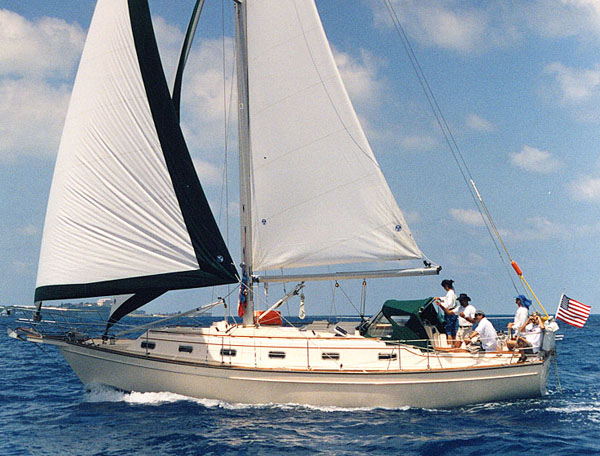
Day 1 of cruise: As the daily destinations were quite aggressive, Capt Lew impressed upon all parties, that even though we may have great winds for sailing, they may not be favorable, ie: direction, etc for meeting the cruise route in a 7 day cruise. We left Taylors Landing Marina at approx. 9:30 am with Cindy at the helm. Mark set up the compass heading needed to make our destination which was a cove in Fishing Bay. Wind was strong out of the North (naturally), and we needed to head directly into it. Waves were approx. 2-3 feet. Therefore, we motored for the first portion of the day. Attempts were made whenever possible to sail, but for the most part it was necessary to motor. Great weather! In passing the York River we reviewed the necessity of being very alert for freighters, separation zones, etc. We arrived, anchored and cooked the first meal of the trip.
Day 2: Raised anchor and set compass headings to pass close abeam of Stingray Point and Windmill Point lights. Students were taking bearings, running fixes, etc as we progressed. After rounding Windmill Point the destination was set towards the Smith Point Light. We progressed for the most part under Yanmar diesel power as the winds were right on the nose. Chartwork was reviewed including symbols, being able to use soundings in helping to locate position, how to look at the landscape to determine where coves, creeks, rivers and other features are located and using haze to help locate position in relationship to the shoreline. The prohibited target area south of Patuxent Naval Air Station was passed outboard of the yellow buoys, and of course there were comments that everyone wanted to see the targets in use. Ha! The marina in the Solomons was contacted via VHF and we tied up at the gas docks per their instructions. The boat was cleaned, and everyone had their first on-shore showers of the trip. This leg of the cruise was rather lengthy and arrival time was early evening. We cooked on board again, and I must say that we have some excellent chefs on this trip.
Day 3: We
waited for the marina's store to open to purchase gifts, ice cream, Snickers
bars for frozen candy bars and left dock shortly thereafter. Rounding Drum Point
at the entrance to the Patuxent and pointing Northward, we found that we could
raise all our sails. We soon found companion boats heading in the same
direction, and soon determined who were the boats racing, and who were the
cruising boats. IE: the old
sailor's adage wherein if we were sailing faster than an adjacent boat we were
racing, and if we happened to be going slower, we were cruising! We found we had
both types accompanying us. A good portion of this leg was under sail for a
change, and close hauled. We also determined during this leg which boats had
people that knew how to sail as boats that should have left us in the dust,
didn't. Much of today's leg was sail trim, currents, tides, and determining what
would allow us to go that one tenth of a knot faster. Again, super weather.
Cindy and Mark were providing the chart work on their personal charts, and were
reviewing the Sharp's Island light and remembering the course, buoy markings
etc, they had pursued during an ASA 104 class to make Annapolis from an
anchorage just off Oxford. The course was toward the Red 2 buoy off the entrance
to Annapolis on the Severn River. We docked in Ego Alley tied up portside-to
along the bulkhead. We took advantage of being in port and ate on shore both
dinner, and breakfast the next morning. Day 4: We
motored out past the Annapolis Spiders marking the entrance into the Bay from
the Severn River and attempted to set sail again. Not possible w/ the winds we
needed, and so motored the distance to Chesapeake City in the C&D canal.
Again, for the most part, Mark and Cindy were taking running fixes, bearings,
chartwork, etc, and looking for familiar landscapes as we passed Rock Hall
during this leg. We tried to spot and call on the VHF to any of the school's
other boats in the area, but didn't connect with any. Another great day, but as
usual, the destination was not appropriate for the winds, etc. The intercoastal
buoy system was reviewed and noted as we passed into the canal. During the
previous day, discussions were held regarding mileage per gallon of fuel, the
boat's capacities of water, fuel, and stowage.
Each hour, in addition to the log entries, the overall ship's condition
was checked. All parties took their turns with cooking, washing dishes and other
ship's chores. Light lists and the newest Notice to Mariners were reviewed to
determine if there were changes made anywhere along the trip. We reviewed man
overboard (MOB) procedures and Rules of the Road which were a constant topic of
discussion particularly when certain navigation/running lights were viewed
during our overnight segments. Lew had made previous arrangements with the
marina at Chesapeake City, and the first thing we did when properly tied up, was
to review the weather channel while grabbing a few cold Iced teas, etc. We
enjoyed a fine dinner at Lew's "special" restaurant when in the area.
Days 5/6: We inspected all rigging again, the boats
supplies, fuel and water supply and motored out of the cove into the C&D
with our destination the Delaware Bay, and a non stop sail to Norfolk/Virgina
Beach. Shortly into the canal, we heard on the emergency calling channel 16,
that a boat had passed rather quickly past Scheaffer's Canal house and had
damaged several boats that were tied up taking on fuel. The Coast Guard was
searching for this boat which created for us a timeframe of trying to find out
if the boat was coming up past us, or going the other way. We never found out,
as the boat returned to the dock to face the insurance exchanges that had to
take place. We understand that one boat that was damaged had the deck completely
separated from the hull along the toe rail.
This was a lesson in itself regarding speed and wake responsibilities. We
had to postpone our transit thru the canal when we noticed the railroad bridge
was down while the bridge tender was awaiting the arrival of a train. Weather
today was developing into a very hazy condition and later proved to be a
full-fledged fog wherein we could not see much further than the length of the
boat. This occurred later in the afternoon when we determined that the Delaware
Bay had entered into the Atlantic. The water temperatures recorded an almost
immediate 10 degree drop from our trip up the Chesapeake and down the Delaware
Bay as compared to the waters of the Atlantic. Also, where we determined the
exchange of waters occurred, we experienced a major effort of our autohelm to
maintain us on the course desired. We could view in the water, a heavy
turbulence in a staggering line paralleling the shore out several miles from the
shore. Discussions throughout the
trip was the comparison of data between the ships log/knotmeter and the Garmin
GPS that Lew was reviewing for a friend. We were determining the directions of
current, etc using this method. As we progressed down the coast approximately 25-30
miles offshore, we intermixed sailing and motoring. We combined this rather
early and with the wind and current helping our progression we were moving
rather fast. In fact, we left Chesapeake City at 8:30 am on Wednesday. and
docked in Virginia Beach at 3:00pm on Thursday afternoon. With the conditions of
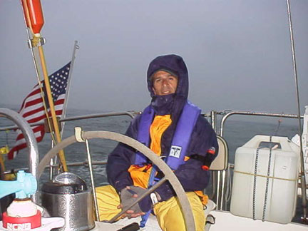
this segment of the sail, we used safety harnesses, jack lines, life jackets,
and storm gear. This section of the trip also brought out the tiredness and some
stress of sailing in fog. I had mentioned several experiences of sailing in fog,
and that I enjoy sailing under these conditions. Some importance of this
condition is to rely 100% on your instruments, the necessity of knowing your
horizon, the listening to the VHF for security calls, and the constant vigil of
a lookout. The signals of various boats moving in fog were reviewed and what
they meant. IE: bell buoys being on the starboard side and the gong buoys being
on the port side while entering, the importance of having a manual device for
making signals as cans of propellant needed for making sounds can be used up
rather quickly, the fact that if a person is being vigilant, he/she can tell the
directions of unseen boat movements, how fast they are moving, are they crossing
the bow, etc.
From 2:30 am onward, we viewed many navigation lights
and determined there were a lot of fishing boats off shore. Likewise, as we
progressed closer to Norfolk, we started seeing larger ships, freighters etc,
and were constantly challenged to determine what they were, if they were moving
off, or were we going to intercept along the way. Our slowest movement was about
6 1/2 knots, and highest was close to 8 this due to the current, and both
methods of power. We plotted our course on the chart each hour, and per Lew's
instructions, stayed within certain constraints along the way. Later, nearing
the separation zones off Norfolk, we hailed a guided missile destroyer on VHF16
which in general is different than when we communicate with other boats along
the way (on channel 13). This I took note as I had been trying to reach it on
channel 13. As we stopped our progression which we would normally have passed in
front of the naval ship to then pass behind, he took note that our sails were
luffing, and asked if "we would want him to accelerate so as to allow us to
continue on our journey without delay". We replied we would appreciate that
kind gesture, and found that when he took off like a dragster at a drag strip
setting up a huge wake, we probably had made a mistake.
The waves from the wake was somewhere near 12-15 feet.
Roller coaster time!
We continued on toward Virginia Beach with Lew taking
the helm to enter the narrow inlet that he was familiar with. The seas all the
way south along the coast were variable from 2 to 4 feet, and although heavy
weather was expected during this segment, we did not encounter the weather
change. We basically had a following sea all the way down the coast. We tied up
and unloaded our gear. I had need of a quick departure, so Lew's friend Wade
took me to the marina from whence we started our circumnavigation.
Mark and Cindy stayed over to take their tests, and passed with flying
colors I am told. Overall comments: I appreciated being able to find
the time to hitch a ride with Lew and to share some of our experiences over our
sailing years. Likewise, the ability of each of us to help back up the others
point of view during times when we needed to bring out elements of the course
was invaluable. ENCHANTMENT
is an excellent boat and the recorded locations of all equipment was a real
great help. I certainly enjoyed the trip. Captain Terry C. Griggs |